
Pricing Change
New pricing for orders of material from this site will come into place shortly. Charges for supply of digital images, digitisation on demand, prints and licensing will be altered.
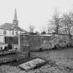
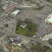
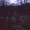
Dingwall, Church Street, St Clement's Church Of Scotland Parish Church, Graveyard


Burial Ground (Medieval)
Site Name Dingwall, Church Street, St Clement's Church Of Scotland Parish Church, Graveyard
Classification Burial Ground (Medieval)
Canmore ID 106029
Site Number NH55NW 47.01
NGR NH 54950 58964
NGR Description Centred NH 54950 58964
Datum OSGB36 - NGR
Permalink http://canmore.org.uk/site/106029


- Council Highland
- Parish Dingwall
- Former Region Highland
- Former District Ross And Cromarty
- Former County Ross And Cromarty
NH55NW 47.01 centred NH 54950 58964
Earth Resistance Survey (8 September 2011 - 10 September 2011)
NH 54936 58988 A geophysical survey was undertaken, 8–10 September 2011, in St Clement’s Parish Church graveyard, as part of a research and community project investigating the archaeology of Dingwall’s Viking assembly site or ‘thing’. An electrical resistance survey was undertaken over the N side of the graveyard in the area surrounding St Clements’s Aisle. The survey aimed to locate the remains of Dingwall Old Parish Church, which was demolished at the end of the 18th century, leaving only the N aisle. The sample density was 1 x 0.5m with probe separation of 0.5m. Three linear high resistance anomalies aligned N–S were recorded to the S of the aisle. These were interpreted as truncated foundations of the W and E walls of the old church nave and the site of a rectangular chancel. A low earthwork SE of the aisle correlates with the geophysical results.
Archive: Highland Council (deposited) and RCAHMS (intended)
Funder: Highland Council, Dingwall History Society and Society of Antiquaries of Scotland
OJT Surveys, 2011

