
Charlestown, Royal Naval Armament Depot, Crombie


Armament Depot (First World War), Armament Depot (20th Century), Armament Depot (Second World War)
Site Name Charlestown, Royal Naval Armament Depot, Crombie
Classification Armament Depot (First World War), Armament Depot (20th Century), Armament Depot (Second World War)
Alternative Name(s) Rnad Crombie; Kinniny Braes; Inner Firth Of Forth
Canmore ID 105821
Site Number NT08SW 104
NGR NT 04796 84102
NGR Description NT 0340 8450 to NT 0587 8400
Datum OSGB36 - NGR
Permalink http://canmore.org.uk/site/105821


- Council Fife
- Parish Torryburn
- Former Region Fife
- Former District Dunfermline
- Former County Fife
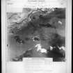
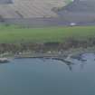
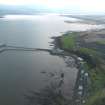
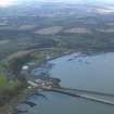
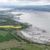
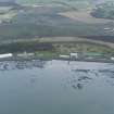
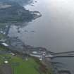
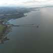
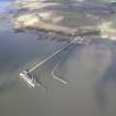
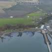
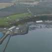
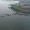
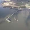
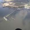
The Royal Naval Armament Depot at Crombie was established just to the west of Rosyth Dockyard. A map of the defences of Crombie dated May 1916 also shows the principal buildings. At this date the Depot seems to have comprised: a line of large roughly square buildings along the foreshore, below the cliff between NT 0370 8429 and NT0450 8421 (four of these either survive or have been replaced on the same footprint); a line of 20 small square buildings along the north side of a track above the cliff (NT 0377 8437 to NT 0449 8418); a group of six buildings to the north and NE of Kinniny Point, from which springs a single jetty (NT104.01) some of which may survive in part); a line of seven small square buildings (NT 1506 8432 to NT 0535 8431). Limited accommodation seems to have been provided, labelled 'military hutments' centred at NT 9469 8438.
The landward side of the Depot was guarded by a barbed wire entanglement and five blockhouses (NT 03367 84673, NT 03790 84672, NT 04650 84375, NT 05147 84441 and NT 05523 84369), and three anti-aircraft positions were marked (at NT 03993 84371, NT 04712 84301 and NT 04733 84328). The blockhouses were made of timber, surrounded by banks of soil.
Information from HS/RCAHMS World War One Audit Project (GJB) 6 September 2013.
NT08SW 104.00 0340 8450 to 0587 8400
Extends onto map sheets NT08NW, and NT08SE.
NT08SW 104.01 from NT 0484 8331 to NT 0473 8395 Pier
NT08SW 104.02 from NT 0371 8406 to NT 0377 8413 Jetty
NT08SW 104.03 from NT 04705 84012 to NT 04715 83211 Jetty
For associated Rosyth Dockyard, see NT08SE 41.00.
Site recorded by Maritime Fife during the Coastal Assessment Survey for Historic Scotland, Kincardine to Fife Ness 1996
Project (March 2013 - September 2013)
A project to characterise the quantity and quality of the Scottish resource of known surviving remains of the First World War. Carried out in partnership between Historic Scotland and RCAHMS.

