
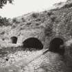
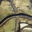
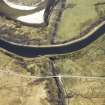
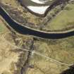
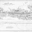
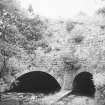
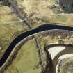
Caledonian Canal, Glen Loy


Canal (Period Unassigned)
Site Name Caledonian Canal, Glen Loy
Classification Canal (Period Unassigned)
Canmore ID 105815
Site Number NN18SW 3
NGR NN 1457 8094
NGR Description NN 1368 8000 to NN 1499 8187
Datum OSGB36 - NGR
Permalink http://canmore.org.uk/site/105815


- Council Highland
- Parish Kilmallie
- Former Region Highland
- Former District Lochaber
- Former County Inverness-shire

