|
Photographs and Off-line Digital Images |
A 57651 |
|
View of Glen Loy Aqueduct |
1983 |
Item Level |
|
|
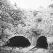
Photographs and Off-line Digital Images |
IN 5884 |
List C Survey |
General view of Glen Loy Aqueduct |
1975 |
Item Level |
|
|
Photographs and Off-line Digital Images |
IND 222/2 |
|
Caledonian Canal - Waggons
Plate 20 copied from the Atlas to the Life of Thomas Telford (1838) |
1838 |
Item Level |
|
|
Photographs and Off-line Digital Images |
IND 222/3 |
|
Cranes used on the Caledonian Canal
Plate 19 copied from the Atlas to the Life of Thomas Telford (1838) |
1838 |
Item Level |
|
|
Photographs and Off-line Digital Images |
IND 222/4 |
|
Caledonian Canal - Machinery of Gates
Plate 18 copied from the Atlas to the Life of Thomas Telford (1838) |
1838 |
Item Level |
|
|
Photographs and Off-line Digital Images |
IND 222/5 |
|
Upper Lock Gates of Timber and of Cast Iron - Caledonian Canal
Plate 17 copied from the Atlas to the Life of Thomas Telford (1838) |
1838 |
Item Level |
|
 |
On-line Digital Images |
DP 015088 |
|
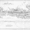
Engraving of elevation and plan inscr: ''Map of the Caledonian Canal or Inland Navigation between the Eastern and Western Sea capable of admitting a frigate of 32 guns.'' Includes longitudinal section. |
|
Item Level |
|
 |
On-line Digital Images |
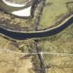
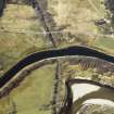
DP 023903 |
RCAHMS Aerial Photography Digital |
Oblique aerial view centred on the canal, aqueduct and road bridge, taken from the NW. |
2/4/2007 |
Item Level |
|
 |
On-line Digital Images |
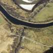
DP 023904 |
RCAHMS Aerial Photography Digital |
Oblique aerial view centred on the canal, aqueduct and road bridge, taken from the WNW. |
2/4/2007 |
Item Level |
|
 |
On-line Digital Images |
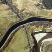
DP 023905 |
RCAHMS Aerial Photography Digital |
Oblique aerial view centred on the canal, aqueduct and road bridge, taken from the SE. |
2/4/2007 |
Item Level |
|
 |
On-line Digital Images |
DP 023906 |
RCAHMS Aerial Photography Digital |
Oblique aerial view centred on the canal, aqueduct and road bridge, taken from the SE. |
2/4/2007 |
Item Level |
|
 |
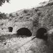
On-line Digital Images |
SC 1642415 |
List C Survey |
General view of Glen Loy Aqueduct |
1975 |
Item Level |
|
 |
On-line Digital Images |
SC 2386339 |
Records of the Ordnance Survey, Southampton, Hampshire, England |
Caledonian Canal, Glen Loy, NN18SW 3, Ordnance Survey index card, Recto |
1958 |
Item Level |
|
 |
On-line Digital Images |
SC 2562516 |
|
View of Glen Loy Aqueduct |
1983 |
Item Level |
|
|
Photographs and Off-line Digital Images |
IND 222/2 (Duplicate) |
|
Caledonian Canal - Waggons
Plate 20 copied from the Atlas to the Life of Thomas Telford (1838) |
1838 |
Item Level |
|


