|
Photographs and Off-line Digital Images |
E 61908 CN |
RCAHMS Aerial Photography |
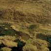
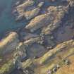
Oblique aerial view centred on the possible enclosure, township, the remains of the buildings and the remains of the dun, taken from the SW. |
23/4/2005 |
Item Level |
|
 |
On-line Digital Images |
SC 1009327 |
RCAHMS Aerial Photography |
Oblique aerial view centred on the possible enclosure, township, the remains of the buildings and the remains of the dun, taken from the SW. |
23/4/2005 |
Item Level |
|
|
Photographs and Off-line Digital Images |
H 92320 PO |
Central Excavation Unit |
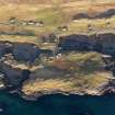
Oblique aerial view centred on the remains of the dun, taken from the SSE. |
1980 |
Item Level |
|
|
Photographs and Off-line Digital Images |
H 92321 PO |
Central Excavation Unit |
Oblique aerial view centred on the remains of the dun, taken from the SSW. |
1980 |
Item Level |
|
 |
On-line Digital Images |
DP 109563 |
RCAHMS Aerial Photography Digital |
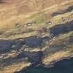
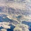
Oblique aerial view of the remains of Dun Innisgall and its causeway, the possible remains of a submerged enclosure at Cairminis and the nearby remains of a head dyke, enclosures and lazy beds, Leverburgh, Harris, taken from the W. |
14/11/2011 |
Item Level |
|
 |
On-line Digital Images |
DP 110636 |
RCAHMS Aerial Photography Digital |
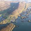
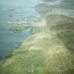
General oblique aerial view of the village and pier at Leverburgh, showing the remains of the township, fish trap, head dyke and lazy beds and the nearby remains of Dun Innisgall, Harris, taken from the WNW. |
14/11/2011 |
Item Level |
|
 |
On-line Digital Images |
DP 110640 |
RCAHMS Aerial Photography Digital |
Oblique aerial view of the remains of Dun Innisgall and its causeway, the possible remains of a submerged enclosure at Cairminis and the nearby remains of a head dyke, enclosures and lazy beds, Leverburgh, Harris, taken from the W. |
14/11/2011 |
Item Level |
|
 |
On-line Digital Images |
DP 110641 |
RCAHMS Aerial Photography Digital |
Oblique aerial view of the remains of Dun Innisgall and its causeway, the possible remains of a submerged enclosure at Cairminis and the nearby remains of a head dyke, enclosures and lazy beds, Leverburgh, Harris, taken from the E. |
14/11/2011 |
Item Level |
|
 |
On-line Digital Images |
SC 1694700 |
RCAHMS Aerial Photography |
Oblique aerial view centred on the possible enclosure, township, the remains of the buildings and the remains of the dun, taken from the SW. |
23/4/2005 |
Item Level |
|
 |
On-line Digital Images |
SC 1967242 |
Papers of James Sloan Bone, landscape historian, Inverness, Highland, Scotland |
Aerial view of Strond/Srannda, Carminish & Leverburgh, South Harris, Hebrides, looking NW. |
6/1985 |
Item Level |
|
|
Digital Files (Non-image) |
WP 007329 |
Records of AOC Archaeology Group, archaeologists, Loanhead, Midlothian, Scotland |
Zipped folder containing data structure report: 'Reconnaissance of a number of eroding midden sites on Lewis, Harris, North Uist and South Uist', March 2003 |
c. 3/2003 |
Item Level |
|
|
Digital Files (Non-image) |
GV 008374 |
Records of AOC Archaeology Group, archaeologists, Loanhead, Midlothian, Scotland |
Vector graphic figure 1: 'Site location map', Midden sites on Lewis, Harris, North Uist and South Uist |
c. 3/2003 |
Item Level |
|
|
Digital Files (Non-image) |
GV 008375 |
Records of AOC Archaeology Group, archaeologists, Loanhead, Midlothian, Scotland |
Vector graphic figure 2 and 3: 'Cultivation deposits at Paible, North Uist' and 'Midden deposits at Baleoch Machair, North Uist', Midden sites on Lewis, Harris, North Uist and South Uist |
c. 3/2003 |
Item Level |
|
 |
On-line Digital Images |
SC 2357850 |
Records of the Ordnance Survey, Southampton, Hampshire, England |
Harris, Carminish, Dun Innisgall, NG08NW 2, Ordnance Survey index card, Recto |
c. 1958 |
Item Level |
|
 |
On-line Digital Images |
SC 2357851 |
Records of the Ordnance Survey, Southampton, Hampshire, England |
Harris, Carminish, Dun Innisgall, NG08NW 2, Ordnance Survey index card, page number 1, Recto |
c. 1958 |
Item Level |
|
 |
On-line Digital Images |
SC 2357852 |
Records of the Ordnance Survey, Southampton, Hampshire, England |
Harris, Carminish, Dun Innisgall, NG08NW 2, Ordnance Survey index card, page number 2, Verso |
c. 1958 |
Item Level |
|
 |
On-line Digital Images |
SC 2357853 |
Records of the Ordnance Survey, Southampton, Hampshire, England |
Harris, Carminish, Dun Innisgall, NG08NW 2, Ordnance Survey index card, Recto |
c. 1958 |
Item Level |
|
|
All Other |
551 5/28/20/1 |
Records of AOC Archaeology Group, archaeologists, Loanhead, Midlothian, Scotland |
Report from excavations at eroding midden sites on North and South Uist |
c. 3/2003 |
Batch Level |
|
|
All Other |
551 5/28/20/2 |
Records of AOC Archaeology Group, archaeologists, Loanhead, Midlothian, Scotland |
Illustrations from excavations at eroding midden sites on North and South Uist |
c. 3/2003 |
Batch Level |
|
|
All Other |
551 166/1/1 |
Records of the Ordnance Survey, Southampton, Hampshire, England |
Archaeological site card index ('495' cards) |
1947 |
Sub-Group Level |
|
|
All Other |
551 5/28/20 |
Records of AOC Archaeology Group, archaeologists, Loanhead, Midlothian, Scotland |
Archive from excavations at eroding midden sites on North and South Uist |
26/2/2002 |
Sub-Group Level |
|


