
Harris, Carminish, Dun Innisgall


Dun (Prehistoric), Midden (Period Unknown), Arrowhead(S) (Flint)(Period Unknown)
Site Name Harris, Carminish, Dun Innisgall
Classification Dun (Prehistoric), Midden (Period Unknown), Arrowhead(S) (Flint)(Period Unknown)
Canmore ID 10513
Site Number NG08NW 2
NGR NG 01964 85243
Datum OSGB36 - NGR
Permalink http://canmore.org.uk/site/10513


- Council Western Isles
- Parish Harris
- Former Region Western Isles Islands Area
- Former District Western Isles
- Former County Inverness-shire
NG08NW 2 01964 85243
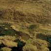
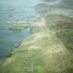
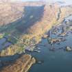
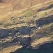
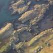
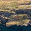
Dun Innisgall: There are slight remains of a dun on the summit of a small tidal island on the N shore of the Sound of Harris, opposite the W end of the township of Carminish. The over-all diameter is c.36ft, and it is connected with the larger, tidal island, which lies outside it to the W, by a causeway, 26 yards long by 6ft broad (RCAHMS 1928). Several flint arrowheads were turned up near this dun during the period of the Highland Destitution. (F W L Thomas 1890)
F W L Thomas 1890; RCAHMS 1928, visited 1914.
The remains of Dun Innisgall occupy the whole of a rocky tidal islet at NG 0194 8521. It has been severely robbed and only the discontinuous outer wall-face can be seen indicating overall measurements of 16.3m E-W by 15.9m N-S. The wall is best preserved on the S side 2-3 courses high, and here it is laid on the top of outcrop rock, 3.5m above HWMMT. On the NW and E the base courses are at the HWMMT. No internal features survive but the wall must have been at least 3.0m thick. Midden material con- taining pottery sherds is visible in the S wall. A causeway, about 2.0m wide and submerged at high tide, joins the islet to a larger island to the SW. Name still known locally. A nodule of grey flint was picked up on the site.
Visited by OS (N K B) 7 July 1969.
Field Visit (8 June 1914)
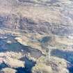
Dun Boraigeo, Strond.
On the northern shore of the Sound of Harris and south-east of the southern end of the township of Strond is Boraigeo Point, a rough rocky point rising 20feet above high-water at the most and surrounded by water for a considerable part of the day. On the landward side are the remains of a stone wall of considerable strength. The rock is so rough and irregular in shape and of such limited area that it could only have provided a temporary refuge for a very small number of people.
RCAHMS 1928, visited 8 June 1914.
OS map: Harris xxvii (unnoted).
Soil Sampling (4 March 2003 - 12 March 2003)
AOC Archaeology were grant aided by Historic Scotland for a second successive season of fieldwork related to a partnership project to assist a PhD studentship investigating the Marine Reservoir Effect, as well as a further project which includes analyses of Plaggan Soils. A total of 25 potential sites were visited to ascertain their potential for sample retrieval relating to the two projects described above.
None of the ecofactual or artefactual material noted at any of the sites visited could be described as being in secure contexts. The material was either within what appeared to be deposits interpreted as topsoil, in unstratified spreads, which were eroding out of the overlying eroding windblown sands, or in the case of Galston within deposits which appeared to have slumped down from above. In light of this no samples were taken for the PhD studentship concerned with the Marine Resevoir Effect. Some soil micromorphological samples were, however, taken in the connection with the study into Plaggan soils. These samples will be reported on at a later date.
AOC Archaeology - Alan Duffy (2003)

