
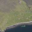
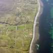
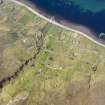
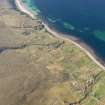
Melvaig


Head Dyke (Post Medieval), Township (Period Unassigned)
Site Name Melvaig
Classification Head Dyke (Post Medieval), Township (Period Unassigned)
Canmore ID 104962
Site Number NG78NW 6
NGR NG 742 866
NGR Description centred on NG 742 866
Datum OSGB36 - NGR
Permalink http://canmore.org.uk/site/104962


- Council Highland
- Parish Gairloch
- Former Region Highland
- Former District Ross And Cromarty
- Former County Ross And Cromarty
Note
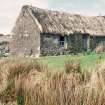
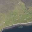
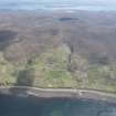
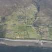
A crofting township comprising seventy-one roofed, three partially roofed, twenty-one unroofed buildings, their associated enclosures and a head-dyke is depicted on the 1st edition of the OS 6-inch map (Ross-shire 1881, sheet xxxi). Forty-eight roofed, three partially roofed, forty-five unroofed buildings, their associated enclosures and a head-dyke are shown on the current edition of the OS 1:10560 map (1969).
Information from RCAHMS (SAH) 17 April 1996

