
Pricing Change
New pricing for orders of material from this site will come into place shortly. Charges for supply of digital images, digitisation on demand, prints and licensing will be altered.
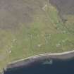
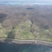
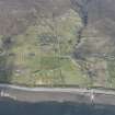
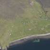
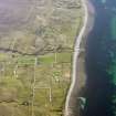
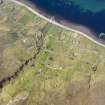
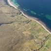
Melvaig


Head Dyke (Post Medieval), Township (Period Unassigned)
Site Name Melvaig
Classification Head Dyke (Post Medieval), Township (Period Unassigned)
Canmore ID 104962
Site Number NG78NW 6
NGR NG 742 866
NGR Description centred on NG 742 866
Datum OSGB36 - NGR
Permalink http://canmore.org.uk/site/104962


- Council Highland
- Parish Gairloch
- Former Region Highland
- Former District Ross And Cromarty
- Former County Ross And Cromarty
Note
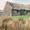
A crofting township comprising seventy-one roofed, three partially roofed, twenty-one unroofed buildings, their associated enclosures and a head-dyke is depicted on the 1st edition of the OS 6-inch map (Ross-shire 1881, sheet xxxi). Forty-eight roofed, three partially roofed, forty-five unroofed buildings, their associated enclosures and a head-dyke are shown on the current edition of the OS 1:10560 map (1969).
Information from RCAHMS (SAH) 17 April 1996

