
Pricing Change
New pricing for orders of material from this site will come into place shortly. Charges for supply of digital images, digitisation on demand, prints and licensing will be altered.
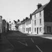
Anstruther Wester, Elizabeth Place, General


General View (Period Unassigned)
Site Name Anstruther Wester, Elizabeth Place, General
Classification General View (Period Unassigned)
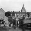
Alternative Name(s) Dreel Bridge
Canmore ID 104859
Site Number NO50SE 169
NGR NO 56419 03519
NGR Description Centred NO 56419 03519
Datum OSGB36 - NGR
Permalink http://canmore.org.uk/site/104859


- Council Fife
- Parish Anstruther Wester
- Former Region Fife
- Former District North East Fife
- Former County Fife
NO50SE 169 centred 56419 03519

