|
Manuscripts |
MS 2954 |
Historic Scotland Archive Project |
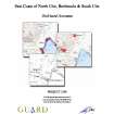
Archive from a coastal zone assessment survey of East Coast of North Uist, Benbecula and South Uist. |
31/3/2006 |
Item Level |
|
 |
Digital Files (Non-image) |
WP 000274 |
Records from the Department of Archaeology, University of Glasgow, Glasgow, Scotland |
Archive from a coastal zone assessment survey of East Coast of North Uist, Benbecula and South Uist. |
31/3/2006 |
Item Level |
|
 |
On-line Digital Images |
DP 111349 |
RCAHMS Aerial Photography Digital |
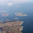
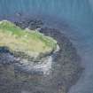
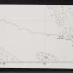
General oblique aerial view of Rubha an Duine, near Lochmaddy, looking towards Hermetray and Vallasay, North Uist, taken from the SW. |
16/11/2011 |
Item Level |
|
 |
On-line Digital Images |
DP 235192 |
Historic Environment Scotland |
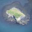
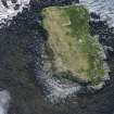
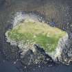
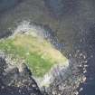
Oblique aerial view. |
2/6/2016 |
Item Level |
|
 |
On-line Digital Images |
DP 235193 |
Historic Environment Scotland |
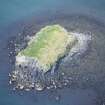
Oblique aerial view. |
2/6/2016 |
Item Level |
|
 |
On-line Digital Images |
DP 235194 |
Historic Environment Scotland |
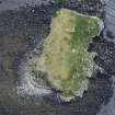
Oblique aerial view. |
2/6/2016 |
Item Level |
|
 |
On-line Digital Images |
DP 235195 |
Historic Environment Scotland |
Oblique aerial view. |
2/6/2016 |
Item Level |
|
 |
On-line Digital Images |
DP 235196 |
Historic Environment Scotland |
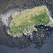
Oblique aerial view. |
2/6/2016 |
Item Level |
|
 |
On-line Digital Images |
DP 235197 |
Historic Environment Scotland |
Oblique aerial view. |
2/6/2016 |
Item Level |
|
 |
On-line Digital Images |
DP 235198 |
Historic Environment Scotland |
Oblique aerial view. |
2/6/2016 |
Item Level |
|
 |
On-line Digital Images |
DP 235199 |
Historic Environment Scotland |
Oblique aerial view. |
2/6/2016 |
Item Level |
|
 |
On-line Digital Images |
SC 2357666 |
Records of the Ordnance Survey, Southampton, Hampshire, England |
North Uist, Groatay, Dun Mhic Laitheann, NF97SE 1, Ordnance Survey index card, Recto |
c. 1958 |
Item Level |
|
 |
On-line Digital Images |
SC 2357667 |
Records of the Ordnance Survey, Southampton, Hampshire, England |
North Uist, Groatay, Dun Mhic Laitheann, NF97SE 1, Ordnance Survey index card, Recto |
c. 1958 |
Item Level |
|
 |
On-line Digital Images |
SC 2357668 |
Records of the Ordnance Survey, Southampton, Hampshire, England |
North Uist, Groatay, Dun Mhic Laitheann, NF97SE 1, Ordnance Survey index card, Recto |
c. 1958 |
Item Level |
|
 |
On-line Digital Images |
SC 2357669 |
Records of the Ordnance Survey, Southampton, Hampshire, England |
North Uist, Groatay, Dun Mhic Laitheann, NF97SE 1, Ordnance Survey index card, Recto |
c. 1958 |
Item Level |
|
 |
On-line Digital Images |
SC 2357670 |
Records of the Ordnance Survey, Southampton, Hampshire, England |
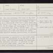
North Uist, Groatay, Dun Mhic Laitheann, NF97SE 1, Ordnance Survey index card, Verso |
c. 1958 |
Item Level |
|
|
All Other |
551 166/1/1 |
Records of the Ordnance Survey, Southampton, Hampshire, England |
Archaeological site card index ('495' cards) |
1947 |
Sub-Group Level |
|


