
Pricing Change
New pricing for orders of material from this site will come into place shortly. Charges for supply of digital images, digitisation on demand, prints and licensing will be altered.
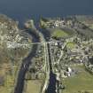
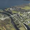
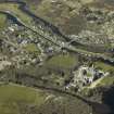
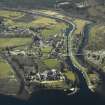
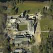
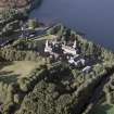
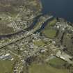
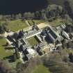
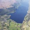
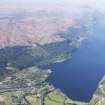
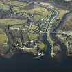
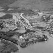
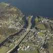
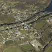
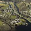
Fort Augustus, Old Fort Augustus


Barracks (18th Century)
Site Name Fort Augustus, Old Fort Augustus
Classification Barracks (18th Century)
Alternative Name(s) Fort Augustus Barracks
Canmore ID 104357
Site Number NH30NE 43
NGR NH 3820 0910
Datum OSGB36 - NGR
Permalink http://canmore.org.uk/site/104357


- Council Highland
- Parish Boleskine And Abertarff
- Former Region Highland
- Former District Inverness
- Former County Inverness-shire
NH30NE Grid Ref: NH 3820 0910
Source: O/S 1:2500 Map, 1966.
The Barracks of Kiliwhiman, built 1718 (now part of the Lovat Arms Hotel - NH30NE 5) were replaced by the 'modern' Fort Augustus, built 1729-42 (Fort Augustus, Old Fort Augustus). The remains of this fort are incorporated into Fort Augustus Abbey and Church (NH30NE 6)
REFERENCE: 1718-19 - James Smith - Board of Ordnance
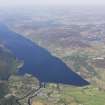
Where the River Oich debouches into the Southern end of Loch NEss.
In the National Library of Scotland is a series of Military Plans and Drawings (many are coloured) of the Board of Ordnance, dealing with the troubled years of the 18th Century, Reference "MSS. 1645-1652". Of Fort Augustus they include, in Case, or Volume, No.1647, the following:-
Number Year
Z.2/61. 1734. "A Plan of Fort Augustus with the Old Barracks and Situation", 1734, with Profile and Explanation. Scale for Plan 100 Feet to an Inch and for Profile 100 Feet to about 2 Inches.
There is also a Copy.
Z.2/62. 1741 "A Plan of Fort Augustus 1741". With References. Scale
40 Feet in an Inch. Docketted on the back as "given by Genl. Clayton to his Grace the Ma.General & laid before the Board 27 Nov. 1741".
There is a copy.
Z.2/63. No date "The Plan of Fort Augustus in the Highlands of Scotland (A modern Fortification copied from the deliniation of Captn John Remer, Engineer)" With References. Includes Elevation of 'The Fore Front of the Maine Gate' and 'The Back Front of the Governeur's House'. Scale 20 Feet to an Inch. There is a note that "This Fortification was begun in 1729 & finished in 1742".
Z.2/64. 1746 "A Plan of Fort Augustus with the proposed additional Works". Scale 50 Feet to an Inch. Docketted as received with Major Lewis Marcell's Estimate.
There is also a sheet of Profiles and Details.
Z.2/65. 1747 "A Plan of Fort Augustus in its present state with a designed Fossee & Cover'd Way" with Profile, and with Explanation.Date 1747. Scale for Plam 40 Feet to an Inch and for Profile 10 Feet to an Inch.
There are two copies.
Z.2/66. 1747 "A Plan of Fort Augustus showing repairs and additions done between June Septmeber 1747 and the Works proposed to be completed in 1748". Scale 100 Feet to an Inch.
Signed by W.Skinner. There are 2 copies.
Z.2/67. 1750 "A Plan of Fort Augustus with the adjacent Lands, 1750"
With Explanation. Scale 200 Feet to an Inch.Bears the name of Daubant, There are 2 copies.
Z.2/68. 1753 "Plan and Sections o the Pier built as Fort Augustus in 1753". Scale 5 Feet to an Inch. Signed by W.Skinner. There is a copy.
There are also in Case, or Volume, No.1650, the following:-
Z.46/23.No date. "Plan of Fort Augustus" and neighbourhood. This is virtually a map to the scale of 400 Feet to an Inch.
Z.46/59.No date. "Plan(s) and Elevation(s) of Mr Stewart's House the Barrack Master at Fort Augustus, etc. With Explanation.
No scale is given. Signed by Thos. Clark.
See also "The Barrack of Kiliwhiman".
There is also in Case, or Volume, No.1646, this Drawing:-
Z.2/31.No date. Small Plans of Fort William, Fort Augustus, and Fort George (Inverness) on the one sheet.
This is also indexed under Fort William and Fort George
(Inverness).

