
Fort William, Corpach, Scottish Pulp And Paper Mills


Paper Mill (Period Unassigned)
Site Name Fort William, Corpach, Scottish Pulp And Paper Mills
Classification Paper Mill (Period Unassigned)
Alternative Name(s) Loch Linnhe; Loch Eil; Annat Point; Corpach Paper Mill; Wiggins Teape Pulp And Paper Mill
Canmore ID 103570
Site Number NN07NE 10
NGR NN 0820 7660
NGR Description Centred NN 0820 7660
Datum OSGB36 - NGR
Permalink http://canmore.org.uk/site/103570


- Council Highland
- Parish Kilmallie
- Former Region Highland
- Former District Lochaber
- Former County Inverness-shire
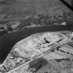
Corpach An early settlement, which later achieved recognition as the terminal basin of the Caledonian Canal, Corpach was developed to house canal workers. It later became Fort William's industrial limb, with a short-lived shipbuilding yard and its most prominent landmark: the Pulp and Paper Mill at Annat, W. S. Atkins and Partners, 1963, the result of a government-backed initiative to bring employment to Lochaber in the 1960s. The Mill harnessed the enormous volumes of water discharged from the aluminium smelter, and helped secure the future of the railway.
Taken from "Western Seaboard: An Illustrated Architectural Guide", by Mary Miers, 2008. Published by the Rutland Press http://www.rias.org.uk

NN07NE 10.00 centred 0820 7660
Scottish Pulp and Paper Mills [NAT]
OS 1:10,00 map, 1975.
NN07NE 10.01 NN 0905 7640 Fort William, Corpach Paper Mill, Jetty
Corpach Paper Mill, S of the A830. By Dennis Ramsbottom of W S Atkins and Partners, 1963-6. Built as a pulp and paper mill; the pulping activity was abandoned in 1980. Buildings covered in aluminium sheeting above a black brick base.
J Gifford 1992.
Field Walking (October 2001)
NN 1191 7702 to NN 0928 7460 A desk-based assessment and walkover survey were carried out in advance of work to lay new sections of water main, totalling approximately 16km, on the N and S shores of Loch Eil. The desk-based assessment identified a single building on the 1st edition OS not noted in the NMRS (NN 0584 7829). The survey identified two sites: a small 19th-century building (NN 0512 7702) and a borrow-pit (NN 0936 7517).
Full report lodged with the NMRS.
Sponsor: Team Aquarius
R Conolly 2001 (Headland Archaeology)

