
Following the launch of trove.scot in February 2025 we are now planning the retiral of some of our webservices. Canmore will be switched off on 24th June 2025. Information about the closure can be found on the HES website: Retiral of HES web services | Historic Environment Scotland
Glasgow, Glasgow Green, Tidal Weir


Weir (20th Century)
Site Name Glasgow, Glasgow Green, Tidal Weir
Classification Weir (20th Century)
Alternative Name(s) River Clyde; 'weir And Pipe Bridge Above Albert Bridge'; Hutchesontown
Canmore ID 103494
Site Number NS56SE 158
NGR NS 59511 64374
Datum OSGB36 - NGR
Permalink http://canmore.org.uk/site/103494


- Council Glasgow, City Of
- Parish Glasgow (City Of Glasgow)
- Former Region Strathclyde
- Former District City Of Glasgow
- Former County Lanarkshire
NS56SE 158 59511 64374
Location formerly cited as NS 5948 6433 to 5954 6441.
For predecessor weirs and navigation lock at or near this location, see NS56SE 2158.
Tidal Weir [NAT]
OS 1:1250 maps, 1966 and 1969.
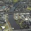
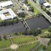
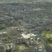
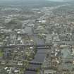
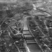
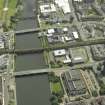
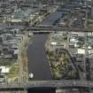
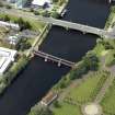
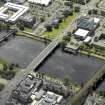
Weir, the fourth on the Clyde at or near this point, marking the upper tidal limit on the river. The Act for its construction was obtained in 1894, and it was opened on 28 December 1901. Sir Benjamin Baker, engineer. There are three movable sluices, each 80ft [24.4m] wide. The steelwork of the weir was reconstructed in the 1940's (completed 13 May 1949), though the masonry is original.
J R Hume 1974.
Weir and pipe bridge above Albert Bridge. The present steel structures, completed in 1949, were supplied by Ransome and Rapier of Ipswich; engineer Robert Bruce (city engineer). Two parallel bridges each carring a large pipe by spandrel-braced arches over three openings. Sluice-gates in the river across thew openings control the flow to maintain a fairly constant depth of water upstream; they are raised and rotated by chains to allow boats to pass under them at full tide. The red sandstone piers and abutments with neat classical details survive from similar sluices also supplied and erected by Ransome and Rapier in 1896-1901, engineer A B McDonald (City Engineer) with Sir Benjamin Baker as consultant; the gates themselves were designed by F G M Stoney. They were built to stop the extensive erosion of the river banks and the siltation in the harbour reaches downstream which resulted from the removal, in 1879, of the first river control works on this site, a fixed weir and navigation lock constructed in 1852.
E Williamson, A Riches and M Higgs 1990.
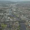
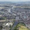
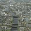
This structure has been built across the River Clyde between Glasgow Green (to the NE) and Hutchesontown (to the SW). It is situated a short distance upstream of Albert Bridge (NS56SE 154) and forms the upper limit of tidal navigation. The river here forms the boundary between the parishes of Glasgow (to the N) and Govan (to the S).
The location assigned to this record defines the centre of the structure. The available map evidence indicates that it extends from NS 59841 64334 to NS 69540 64418.
Information from RCAHMS (RJCM), 16 June 1996 and 16 December 2005.
Publication Account (1949)
This weir consists of three spans of spandrel braced steel arches erected in 1949 to carry machinery for raising and lowering gates to control the flow of water and its level upstream. They can be raised at high tide to allow the passage of small boats. The engineer was Robert Bruce, City Engineer, and the contractor, Crowley Russell.
R Paxton and J Shipway 2007
Reproduced from 'Civil Engineering heritage: Scotland - Lowlands and Borders' with kind permission of Thomas Telford Publishers.
Project (2007)
This project was undertaken to input site information listed in 'Civil engineering heritage: Scotland - Lowlands and Borders' by R Paxton and J Shipway, 2007.

