
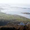
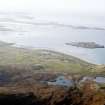
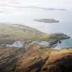
North Uist, Port Nan Long


Cist(S) (Bronze Age), Cist (Early Bronze Age), Cremation (Early Bronze Age), Midden (Prehistoric) - (Post Medieval), Settlement (Prehistoric) - (Post Medieval)(Possible), Cinerary Urn (Pottery)(Early Bronze Age), Rivet(S) (Viking)
Site Name North Uist, Port Nan Long
Classification Cist(S) (Bronze Age), Cist (Early Bronze Age), Cremation (Early Bronze Age), Midden (Prehistoric) - (Post Medieval), Settlement (Prehistoric) - (Post Medieval)(Possible), Cinerary Urn (Pottery)(Early Bronze Age), Rivet(S) (Viking)
Alternative Name(s) Cnoc Raineach; Newtonferry
Canmore ID 10315
Site Number NF87NE 6
NGR NF 8990 7820
NGR Description Centred on NF 8990 7820
Datum OSGB36 - NGR
Permalink http://canmore.org.uk/site/10315


- Council Western Isles
- Parish North Uist
- Former Region Western Isles Islands Area
- Former District Western Isles
- Former County Inverness-shire
NF87NE 6 899 782.
(Area : NF 900 784) Several ruined cists have been found by Beveridge on the sandy slope at Rudha na Traghad, a little to the east of Port nan Long. One contained an inverted urn with evidence of a cremated burial. The vessel had a crudely incised ornamental design on its flat base and nearby was a circular flat stone which would fit exactly the inverted mouth.
The quantity of potsherds over the area suggested a kiln, and in addition iron slag and red ashes were found, as if from a furnace.
Other finds included bone pinds, bronze brooches, two pieces of flint, boat rivets of Viking type etc., and part of a small clay crucible. (E Beveridge 1911)
The finds are in the National Museum of Antiquities of Scotland (NMAS).
E Beveridge 1911; Proc Soc Antiq Scot 1912; 1922; 1948.
Nothing was seen of the cists, but there is an extensive spread of midden material and fragmentary building remains in the area of open dune centred at NF 8992 7820.
Visited by OS (J T T) 26 June 1965.
Field Visit (15 August 1914)
Stone setting, Rudha na Traghad, Port nan Long.
On a wind-swept, sandy slope on the east side of the bay and some 400 yards east of Port nan Long, is a considerable quantity of displaced stones, amongst which are a number of small slabs set on end. Two of the latter, measuring 2 feet 3 inches in height by 2 feet 5 inches in length and 1 foot 11 inches in height by 2 feet in length, are placed in line facing a similar stone, 2 feet 6 inches high by 2 feet long, some 8 feet to the east. Stretching up the slope from the last slab, towards the north-north-east over a distance of 35 feet 6 inches, are a number of smaller boulders and three smaller slabs set on end in line, while some 14 feet to the south lower down the hill is the outer foundation course of a curved stone wall which seems to have encircled the structure. Immediately outside this wall is a hearth of burnt sandy clay, and the whole site is covered by a slight sprinkling of kitchen midden refuse and broken pottery.
Upon the sandy slope at Rudha na Traghad Dr Beveridge found a small cist, apparently not more than 2 feet in length, containing an inverted urn 6 inches high and widening from 4 ½ inches to 5 ¼ inches. The base of the urn is crudely ornamented. Close to the urn was a disc of stone which would fit the mouth (North Uist, p.268).
RCAHMS 1928, visited 15 August 1914
OS map: North Uist xxxi (unnoted)
Excavation (1984)
A midden was traced up to 40 m from the beach and for a length of over 100m. A section cut across the exposed midden face revealed dark stained sand and midden deposits to a depth of about 1.5 m. Possible stone wall foundations seen within the eroded debris were of post-medieval date.
J Barber, 1984.
Field Visit (4 July 2016 - 28 July 2016)
NF 86724 74207 – NF 90176 78707 A programme of archaeological work was undertaken, 4–28 July 2016, prior to and during the installation of a new overhead electricity line. A total of 44 archaeological sites were identified during the walkover survey. Eight of these were previously known. New sites consisted of a farmstead (NF 88138 75912), and a mound (NF 88128 75878). In addition, 23 dykes, 3 enclosures, 4 structures, 3 quarries and a clearance cairn, all previously unrecorded, were also noted.
The watching brief on the sites for four poles also recorded a number of archaeological deposits. A cockle midden was noted during work on Pole 5 (cNF 86844 74333). A number of finds were also recovered during the excavation of the stay trench, including glazed pottery sherds, metal fixtures, and a piece of shaped slate. All were consistent with a 19th-century date.
Further ash-rich and shell-rich midden deposits were recorded in the main excavations for Pole 87. These deposits produced fragments of unworked animal bone, a variety of marine shell, and sherds of undecorated coarse pottery. Worked quartz and a fire-cracked cobble were also recovered.
The Pole 87 stay trench also contained midden layers sealing a hammerstone and a small pit cut into the natural.
Excavations at Pole 86 revealed an area of masonry as well as some small cut features. Deposits in the trench also contained some ironwork
Finally, midden deposits were found at NF 90059 78390 close to Pole 89.
It is thought that the deposits and structure noted at Poles 86, 87 and 89 relate to Iron Age and Norse remains. These seem to extend across an area of machair for at least 70m and were previously recorded as Canmore ID: 10315.
Archive: Western Isles HER and NRHE
Funder: SSE Power Distribution
Lachlan McKeggie and Kate MacDonald – Highland Archaeology Services
(Source: DES, Volume 18)
Note (2020)
Port Nan Long
This burial site in Western Isles was a focus for funerary practices in the Bronze Age period, between 2200 BC and 1501 BC.
Prehistoric Grave Goods project site ID: 60163
CANMORE ID: 10315
Total no. graves with grave goods: 1
Total no. people with grave goods: 1
Total no. grave goods: 2
Prehistoric Grave Goods project Grave ID: 60056
Grave type: Cist
Burial type(s): Cremation
Grave good: Pot (Unknown/Unspecified)
Materials used: Pottery
Current museum location: Unknown
Grave good: Lid
Materials used: Stone (Uncertain/Unspecified)
Current museum location: Unknown
Further details, the full project database and downloads of project publications can be found here: https://doi.org/10.5284/1052206
An accessible visualisation of the database can be found here: http://blogs.reading.ac.uk/grave-goods/map/

