
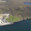
Kebister


Clearance Cairn(S) (Period Unassigned), Field System (Period Unassigned), Rig And Furrow (Medieval), Structure(S) (Period Unassigned)
Site Name Kebister
Classification Clearance Cairn(S) (Period Unassigned), Field System (Period Unassigned), Rig And Furrow (Medieval), Structure(S) (Period Unassigned)
Canmore ID 1014
Site Number HU44NE 10
NGR HU 4585 4550
NGR Description From HU 4560 4535 to 4610 4560
Datum OSGB36 - NGR
Permalink http://canmore.org.uk/site/1014


- Council Shetland Islands
- Parish Tingwall
- Former Region Shetland Islands Area
- Former District Shetland
- Former County Shetland
HU44NE 10 Centred at 4585 4550
Part of the Kebister Township, see HU44NE 11.00.
There are intricate field systems, including sub-peat dykes, over a wide area around Kebister settlement (HU44NE 5, at HU 457 455).
O Owen and C Lowe 1987.
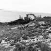
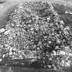
Six distinct groups of cultivation rigs were recorded, all within the area enclosed by the March Dyke (HU44NE 11.01) and likely to be post-medieval in date. The longest are more than 150m in length. The rigs vary in width from 5-10m but are mostly nearer 5m. Cultivation remains are clearly contained within a field (Enclosure 7 in the published report) (see HU44NE 11). 17 field clearance cairns were recorded, most of them on the coastal plain below 25m OD.
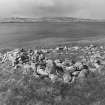
33 dykes of various types and lengths demonstrate a complex history of land management. The dykes served a variety of functions as feld-edges, field boundations and perhaps other enclosure boundaries. Historical and radiocarbon dating indicates that major dykes were constrcuted at least in the medieval, late medieval and post-medieval periods.
Three rectangular structures (Strucures 13-15 in the published report) lie upslope of the cultivation remains, close to the March Dyke, are interpreted as medieval turf-walled plantie crub (upslope enclosures in which crops such as cabbage or kail were sown in late summer.
O Owen and C Lowe 1999.
The excavation archive from Kebister has been catalogued. The archive consists of manuscripts, photographic material and drawings. Digital and audio archive is available and consists of drafts of the Kebister 1999 monograph, the stone catalogues, the key for the soil maps, mini data cartridges containing 'Kebister modified files' and a recorded conversation with Mr and Mrs Anderson.
Historic Scotland Archive Project (SW) 2001
Field Visit (20 November 2012 - 23 November 2012)
HU 46120 45660 to 45910 45252 (within site boundary)
The March Dyke is associated with Handigarth, an abandoned settlement located some 180m to the west of the site boundary. It was fully surveyed during the excavations at Kebister in the 1980s) (Owen and Lowe 1999). It is approximately 1100m long of which some 460m lies within the site boundary. The dyke is built from turf and stone, and is some 1.2m wide and up to 0.4m high.
HU 45984 45442 to 45951 45450
A 35m long segment of a sub-peat dyke is located some 60m inside the March Dyke. It is 1.2m wide and up to 0.25m high and aligned east-west. The dyke was fully surveyed during the excavations at Kebister in the 1980s.
HU 45965 45361 to 45906 45390 (within site boundary)
This dyke roughly parallel with and located some 80m to the south of Site 6. It is 1.5m wide and up to 0.2m high. The dyke was fully surveyed during the excavations at Kebister in the 1980s and extends beyond the site boundary to the west.
HU 45986 45347
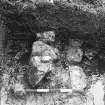
A sub-rectangular enclosure is located some 15m outside the March Dyke. It measures some 7m by 4m internally and is defined by low banks 1.7m to 2m wide and 0.1m high. The entrance is located at the northwestern corner. There are remains of a cross-bank located towards the west end of the structure. The feature was surveyed during the excavations at Kebister in the 1980s. At the time a slot was cut through the bank of the enclosure that indicated that it was turf-built.
HU 45957 45270
A possible hut-platform is located outside the March Dyke on the north side of a knoll some 75m to the south of Site 8. It is defined by a scoop into the hillside with a corresponding bulge down slope forming a near level area some 7m by 6m. The feature was recorded during the excavations at Kebister in the 1980s. A small trench in the interior was excavated at the time exposing a layer of medium stones. The layer was thought to be anthropogenic in origin indicating that this is a manmade feature.
Information from OASIS ID: headland1-142396 (M Dalland) 2012

