
Pricing Change
New pricing for orders of material from this site will come into place shortly. Charges for supply of digital images, digitisation on demand, prints and licensing will be altered.
North Uist, Dun Scarie


Building(S) (Medieval), Causeway (Prehistoric), Dun (Prehistoric)
Site Name North Uist, Dun Scarie
Classification Building(S) (Medieval), Causeway (Prehistoric), Dun (Prehistoric)
Alternative Name(s) Scaraidh
Canmore ID 10128
Site Number NF77SW 8
NGR NF 71780 70559
Datum OSGB36 - NGR
Permalink http://canmore.org.uk/site/10128


- Council Western Isles
- Parish North Uist
- Former Region Western Isles Islands Area
- Former District Western Isles
- Former County Inverness-shire
Publication Account (1911)
Dun Scarie, 400 yards to the north of Sithean Tuath, stands upon an island near the west coast of Loch Scarie, and is connected with the shore by a slightly curved causeway 6 feet wide and 34 yards in length. When the writer first visited this site in 1897, he found a neighbouring cottage newly erected with stones quarried out of Dun Scarie, and was also informed that Balranald House had been partly built with materials taken from the same source. A single fragment of ancient pottery, with some bones, perwinkle shells, and hammer-stones, were the sole relics observed here. The main structure seems to have been rectangular in general outline, but with rounded corners and its interior divided into three compartments. The site is however so indistinct as not to afford data for precise measurements.
Erskine Beveridge 1911, 190
Field Visit (6 August 1915)
Dun Scarie, Loch Scarie, Balranald.
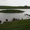
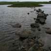
Near the middle of the western shore of Loch Scarie, some ½ mile north by west of Balranald, is an islet crowned by the scanty remains of Dun Scarie. Only an irregular mound, rising some 7 feet above the water, crowned with the rectangular foundations of late buildings, is to be seen. No structure remains in position to give any indication of the character or dimensions of the dun, but the islet is now after a partial drainage of the loch about 100 feet in diameter. A causeway 113 feet in length, with a slight curve in its course, connects the dun with the western shore of the loch. The stones of this work are spread over a width of about 12 feet, but originally it has not exceeded 6 feet.
RCAHMS 1928, visited 6 August 1915.
OS map: North Uist xxxiii.
Desk Based Assessment (14 January 1965)
(NF 7178 7055) Dun Scarie (NR)
OS 6" map, Inverness-shire, 2nd ed., (1904)
Dun Scarie stands on an island near the west side of Loch Scarie, connected to the shore by a causeway. The main structure seems to have been rectangular, with rounded corners, but it has been extensively robbed.
A single fragment of pottery, some bones and shells, and hammerstones were the only finds.
Information from OS (BRS) 14 January 1965
E Beveridge 1911.
Field Visit (16 June 1965)
All that remains of Dun Scarie is a mutilated turf-covered mound, c 1.2m high, with, on its summit, the remains of a later building, obliterating most details of the dun.
Surveyed at 1/2500.
The causeway is now partly submerged.
Visited by OS (J T T) 16 June 1965.
Field Visit (19 September 2012)
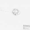
The heavily robbed remains of a dun, overlain by at least three rectangular buildings, are situated on an islet in Loch Scaridh, connected to the W shore of the loch by a massive causeway measuring about 37m in length and 3m in breadth. The dun measured about 22m in diameter over a wall which stands up to 2m in height but it has been so comprehensively modified that neither its original thickness nor the position of the entrance is now clear.
The largest of the three buildings overlies the centre of the dun and measures about 10.6m from E to W by 6.5m transversely over grass-grown stone walls 0.5m in thickness. The second building was situated on a level stance cut though the dun wall immediately to the S, but it has been almost completely removed. Robber trenches on the N and W indicate that it originally measured about 8.5m from E to W by 6m overall. The third building overlies the dun wall on the SW. Less regular in plan than the other two, it measures about 8m from N to S by 5m transversely over grass-grown wall-footings. The quarrying noted by Beveridge (1911, 190) is apparent both in the robbing of the dun, particularly on the N and E where conspicuous quarry-scoops are visible in the wall, and of the buildings.
Visited by RCAHMS (GFG, AW) 19 Sept 2012.
Measured Survey (15 September 2012)
RCAHMS surveyed the dun and settlement at Dun Scarie on 15 September 2012 with plane-table and alidade producing a plan at a scale of 1:250.

