
Following the launch of trove.scot in February 2025 we are now planning the retiral of some of our webservices. Canmore will be switched off on 24th June 2025. Information about the closure can be found on the HES website: Retiral of HES web services | Historic Environment Scotland
Dundee History


05/01/2012
RCAHMS has been working with the National Library of Scotland and the ‘Scotsman’ newspaper to tell the stories of the nation’s cities.
From intricate seventeenth century sketches and eighteenth century town plans, to pioneering Victorian photography and modern aerial survey imagery, the material from the RCAHMS National Collection is being used to produce visual timelines of the history of Scotland’s major cities and towns.
You can browse and buy all the imagery featured in the supplements – plus a lot more – in our series of galleries and through our online, searchable database of architecture and archaeology, Canmore.


SC 369048
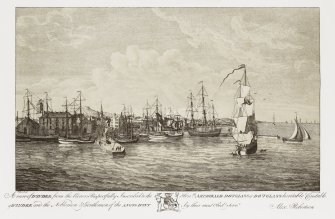
Photograph of drawing of general view of works. insc. 'Tay Works, Dundee. Messrs Gilroy,Sons and Co. Limited. Jute Spinners and Manufacturers.'
© RCAHMS

SC 642515
Un-executed design for front elevation of Morgan Academy, Forfar Road.
© Courtesy of HES (Records of Dick Peddie and McKay, architects, Edinburgh, Scotland)

SC 642516
Detail of dormer window in main tower of Morgan Academy, Forfar Road.
© Courtesy of HES (Records of Dick Peddie and McKay, architects, Edinburgh, Scotland)

SC 642811
View taken from the fire-fighters extendable platform, after the fire was extinguished at Morgan Academy, 22 March 2001. Threatened Buildings Survey photograph Scanned image of E 5758 CN.
© Courtesy of HES (Records of Dick Peddie and McKay, architects, Edinburgh, Scotland)


SC 656466
Detailed view of the Tay Railway Bridge, Dundee, from SE of the steel piers and girders forming the south end of the bridge, with the foundations of the earlier bridge visible (right).
© Crown Copyright: HES


SC 691899
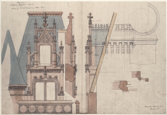
Elevation of Victoria Royal Arch for competition.
© Courtesy of HES (Records of Dick Peddie and McKay, architects, Edinburgh, Scotland)


SC 884118
General view from South-West. Insc: 'Old Trades Hall. High Street. Dundee. 1494. J.V'.
© Courtesy of HES (J Valentine and Sons)

SC 933814
Detail of dormers and chimney stacks on SW elevation of Morgan Academy.
© Crown Copyright: HES

DP 001122
Design for decorative motif showing trumpeting angel at Nethergate, Dundee.
© Courtesy of HES (Records of Scott Morton and Company, woodwork designers, Edinburgh, Scotland)


DP 007961
General oblique aerial view looking across the Firth of Tay and the road bridge towards the city of Dundee, taken from the SSE.
© Crown Copyright: HES

DP 017828
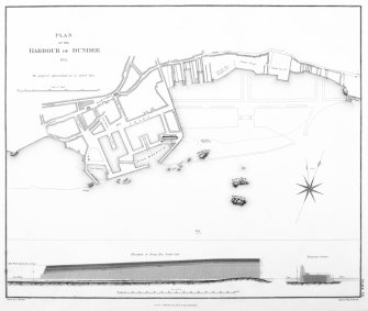
Engraving of elevation and plan inscr: ''Plan of the Harbour of Dundee 1832. The proposed improvements are in dotted line.''
© Courtesy of HES (Illustrations in 'Atlas to the Life of Thomas Telford, civil engineer', 1838)

SC 1114598
Oblique aerial view centred on the City Churches, Nethergate and adjacent construction, taken from the SE.
© Crown Copyright: HES


DP 043764
Drawing showing South elevation of Old Medical School, Small's Wynd.
© Courtesy of HES (Records of Findlay, Stewart and Robbie, architects, Dundee, Scotland)

SC 1132310
Painting showing a perspective view of Camperdown Flax Mill and Linen Works, Dundee.
© RCAHMS


SC 1132328
General view of Victoria Royal Arch, Dock Street, Dundee.
© Crown Copyright: HES (Scottish National Buildings Record)

SC 1132331
Historic photograph showing a general view. Insc: 'Royal Arch, Dundee. 1626. J.V'.
© Courtesy of HES (J Valentine and Sons)

SC 1132336
General view of Ward Mills, Dundee prior to demolition.
© Crown Copyright: HES (Scottish National Buildings Record)


DP 052688
Crawford's Plan of the Town and Harbour of Dundee 1776 From 'Dundee, Its Quaint and Historic Buildings' by AC Lamb
© RCAHMS

DP 052778
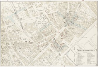
Government Survey Plan of Dundee, 1858 From 'Dundee, Its Quaint and Historic Buildings' by AC Lamb
© RCAHMS

DP 052780
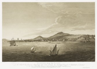
Slezer's View of Dundee (From the East) Reproduced from Slezer's Theatrum Scotiae From 'Dundee, Its Quaint and Historic Buildings' by AC Lamb
© RCAHMS

DP 052790
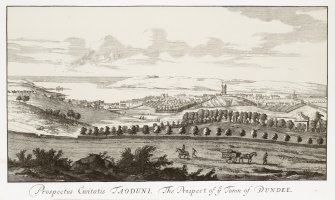
Slezer's View of Dundee (From the North) Reproduced from Slezer's 'Theatrum Scotiae' From 'Dundee, Its Quaint and Historic Buildings' by AC Lamb
© RCAHMS

DP 052808
Methven's View of Dundee Harbour c.1780 From 'Dundee, Its Quaint and Historic Buildings' by AC Lamb
© RCAHMS

DP 052825
Dundee from the River, 1803 by Daniel Orme From 'Dundee, Its Quaint and Historic Buildings' by AC Lamb
© RCAHMS

DP 052848
Dundee from the West, 1803, by Daniel Orme From 'Dundee, Its Quaint and Historic Buildings' by AC Lamb
© RCAHMS


DP 075691
Oblique aerial view centred on Ninewells Hospital, taken from the SW.
© Crown Copyright: HES

DP 075721
Oblique aerial view centred on Tannadice Park and Dens Park, Dundee, taken from the ESE.
© Crown Copyright: HES

DP 075736
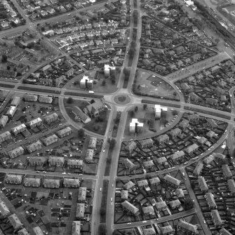
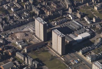
Oblique aerial view centred on Maxwell Town and Carnegie tower blocks, taken from the SE.
© Crown Copyright: HES

DP 075745
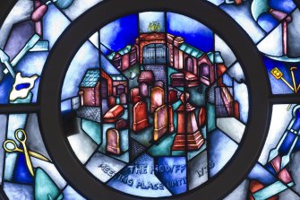
Oblique aerial view centred on Ward Road with The Houff burial old ground adjacent, taken from the SW.
© Crown Copyright: HES


DP 075749
Oblique aerial view centred on Gilfillan Memorial Church, taken from the SE.
© Crown Copyright: HES

DP 075752
General oblique aerial view centred on the mills of Lochee Road taken from the ESE.
© Crown Copyright: HES


DP 075775
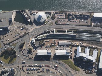
Oblique aerial view centred on Discovery Point with the museum and the ship adjacent, taken from the NW.
© Crown Copyright: HES


DP 093222
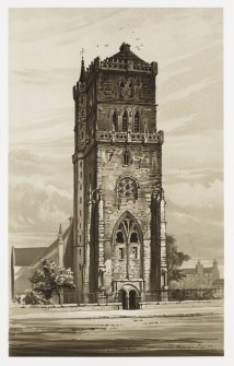
Interior of St Andrew's Church. Gallery level, N wall, detail of stained glass
© Crown Copyright: HES

DP 093224
Interior of St Andrew's Church. Gallery level, N wall, detail of stained glass
© Crown Copyright: HES

DP 093407
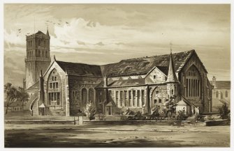
Interior of St Paul's Episcopal Cathedral. Nave and Chancel. View from NW
© Crown Copyright: HES


DP 099820
North elevation showing level of floor at entrance porch of St Mark's Church
© Courtesy of HES (Records of Dundee Police Commissioners, The Corporation of Dundee, Scotland)


DP 101005
Victoria Road, Dundee, PHOTOGRAPH ALBUM No.67: Dundee Valentine Album.
© Courtesy of HES (J Valentine and Sons)

DP 101006
Victoria Road lookiing west from foot of Nelsion Street. J.V. PHOTOGRAPH ALBUM No.67: Dundee Valentine Album.

DP 101008
Nethergate, looking from the top of Union Street to the High Street, J.V. PHOTOGRAPH ALBUM No.67: Dundee Valentine Album.


DP 101618
Tay Bridge from S, (after accident) 1865, J.V. PHOTOGRAPH ALBUM No.67: Dundee Valentine Album.

DP 101635
Victoria Bridge, South Side, as seen from within Den's Works. PHOTOGRAPH ALBUM No.67: Dundee Valentine Album


SC 369048
Photograph of drawing of general view of works. insc. 'Tay Works, Dundee. Messrs Gilroy,Sons and Co. Limited. Jute Spinners and Manufacturers.'
© RCAHMS
SC 642515
Un-executed design for front elevation of Morgan Academy, Forfar Road.
© Courtesy of HES (Records of Dick Peddie and McKay, architects, Edinburgh, Scotland)
SC 642516
Detail of dormer window in main tower of Morgan Academy, Forfar Road.
© Courtesy of HES (Records of Dick Peddie and McKay, architects, Edinburgh, Scotland)
SC 642811
View taken from the fire-fighters extendable platform, after the fire was extinguished at Morgan Academy, 22 March 2001. Threatened Buildings Survey photograph Scanned image of E 5758 CN.
© Courtesy of HES (Records of Dick Peddie and McKay, architects, Edinburgh, Scotland)
SC 656466
Detailed view of the Tay Railway Bridge, Dundee, from SE of the steel piers and girders forming the south end of the bridge, with the foundations of the earlier bridge visible (right).
© Crown Copyright: HES
SC 691899
Elevation of Victoria Royal Arch for competition.
© Courtesy of HES (Records of Dick Peddie and McKay, architects, Edinburgh, Scotland)
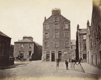
SC 884118
General view from South-West. Insc: 'Old Trades Hall. High Street. Dundee. 1494. J.V'.
© Courtesy of HES (J Valentine and Sons)
SC 933814
Detail of dormers and chimney stacks on SW elevation of Morgan Academy.
© Crown Copyright: HES
DP 001122
Design for decorative motif showing trumpeting angel at Nethergate, Dundee.
© Courtesy of HES (Records of Scott Morton and Company, woodwork designers, Edinburgh, Scotland)
DP 007961
General oblique aerial view looking across the Firth of Tay and the road bridge towards the city of Dundee, taken from the SSE.
© Crown Copyright: HES
DP 017828
Engraving of elevation and plan inscr: ''Plan of the Harbour of Dundee 1832. The proposed improvements are in dotted line.''
© Courtesy of HES (Illustrations in 'Atlas to the Life of Thomas Telford, civil engineer', 1838)
SC 1114598
Oblique aerial view centred on the City Churches, Nethergate and adjacent construction, taken from the SE.
© Crown Copyright: HES
DP 043764
Drawing showing South elevation of Old Medical School, Small's Wynd.
© Courtesy of HES (Records of Findlay, Stewart and Robbie, architects, Dundee, Scotland)
SC 1132310
Painting showing a perspective view of Camperdown Flax Mill and Linen Works, Dundee.
© RCAHMS
SC 1132328
General view of Victoria Royal Arch, Dock Street, Dundee.
© Crown Copyright: HES (Scottish National Buildings Record)
SC 1132331
Historic photograph showing a general view. Insc: 'Royal Arch, Dundee. 1626. J.V'.
© Courtesy of HES (J Valentine and Sons)
SC 1132336
General view of Ward Mills, Dundee prior to demolition.
© Crown Copyright: HES (Scottish National Buildings Record)
DP 052688
Crawford's Plan of the Town and Harbour of Dundee 1776 From 'Dundee, Its Quaint and Historic Buildings' by AC Lamb
© RCAHMS
DP 052778
Government Survey Plan of Dundee, 1858 From 'Dundee, Its Quaint and Historic Buildings' by AC Lamb
© RCAHMS
DP 052780
Slezer's View of Dundee (From the East) Reproduced from Slezer's Theatrum Scotiae From 'Dundee, Its Quaint and Historic Buildings' by AC Lamb
© RCAHMS
DP 052790
Slezer's View of Dundee (From the North) Reproduced from Slezer's 'Theatrum Scotiae' From 'Dundee, Its Quaint and Historic Buildings' by AC Lamb
© RCAHMS
DP 052808
Methven's View of Dundee Harbour c.1780 From 'Dundee, Its Quaint and Historic Buildings' by AC Lamb
© RCAHMS
DP 052825
Dundee from the River, 1803 by Daniel Orme From 'Dundee, Its Quaint and Historic Buildings' by AC Lamb
© RCAHMS
DP 052848
Dundee from the West, 1803, by Daniel Orme From 'Dundee, Its Quaint and Historic Buildings' by AC Lamb
© RCAHMS
DP 073894
View of the remains of the Old Tay Bridge after the disaster of December 1879. Titled: 'Tay Bridge'.
DP 075638
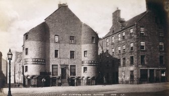
General view of Old Custom House, Dundee showing the premises of John S Bradford and Charles Robertson butcher
DP 075691
Oblique aerial view centred on Ninewells Hospital, taken from the SW.
© Crown Copyright: HES
DP 075721
Oblique aerial view centred on Tannadice Park and Dens Park, Dundee, taken from the ESE.
© Crown Copyright: HES
DP 075736
Oblique aerial view centred on Maxwell Town and Carnegie tower blocks, taken from the SE.
© Crown Copyright: HES
DP 075745
Oblique aerial view centred on Ward Road with The Houff burial old ground adjacent, taken from the SW.
© Crown Copyright: HES
DP 075749
Oblique aerial view centred on Gilfillan Memorial Church, taken from the SE.
© Crown Copyright: HES
DP 075752
General oblique aerial view centred on the mills of Lochee Road taken from the ESE.
© Crown Copyright: HES
DP 075775
Oblique aerial view centred on Discovery Point with the museum and the ship adjacent, taken from the NW.
© Crown Copyright: HES
DP 082347
General oblique aerial view lookings along the Firth of Tay with the bridges and Dundee in the distance, taken from the NE.
© Crown Copyright: HES
DP 093222
Interior of St Andrew's Church. Gallery level, N wall, detail of stained glass
© Crown Copyright: HES
DP 093224
Interior of St Andrew's Church. Gallery level, N wall, detail of stained glass
© Crown Copyright: HES
DP 093407
Interior of St Paul's Episcopal Cathedral. Nave and Chancel. View from NW
© Crown Copyright: HES
DP 099820
North elevation showing level of floor at entrance porch of St Mark's Church
© Courtesy of HES (Records of Dundee Police Commissioners, The Corporation of Dundee, Scotland)
DP 101005
Victoria Road, Dundee, PHOTOGRAPH ALBUM No.67: Dundee Valentine Album.
© Courtesy of HES (J Valentine and Sons)
DP 101006
Victoria Road lookiing west from foot of Nelsion Street. J.V. PHOTOGRAPH ALBUM No.67: Dundee Valentine Album.
DP 101008
Nethergate, looking from the top of Union Street to the High Street, J.V. PHOTOGRAPH ALBUM No.67: Dundee Valentine Album.
DP 101014
Extended Meadowside (Old Water Wynd) 1877, J.V. PHOTOGRAPH ALBUM No.67: Dundee Valentine Album.
DP 101618
Tay Bridge from S, (after accident) 1865, J.V. PHOTOGRAPH ALBUM No.67: Dundee Valentine Album.
DP 101635
Victoria Bridge, South Side, as seen from within Den's Works. PHOTOGRAPH ALBUM No.67: Dundee Valentine Album
