Following the launch of trove.scot in February 2025 we are now planning the retiral of some of our webservices. Canmore will be switched off on 24th June 2025. Information about the closure can be found on the HES website: Retiral of HES web services | Historic Environment Scotland
Field Visit


Date 15 April 1957
Event ID 927564
Category Recording
Type Field Visit
Permalink http://canmore.org.uk/event/927564
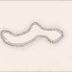
Fort, Doune.
This fort occupies a serpentine hill named Doune on the O. S. map which rises to a height of a little over 800 feet O. D. close to the right bank of the River Findhorn, half a mile S. of Bridge of Dulsie. It commands a fairly extensive view in all directions, including the lower part of that section of the valley of the River Findhorn which is known as Streens and which forms a pass to Strathdearn. To N., E. and S. the flanks of the hill are steep but not precipitous, but the approach from the W. is much easier. The summit of the hill must always have been comparatively level, but was doubtless made more so when it was under the plough. The farmer at Dunearn stated that cultivation had ceased in 1906 but until that date had been carried on for some considerable time. As a result of this, in addition to the normal processes of stone robbing and decay, the remains of the fort are slight. The level summit area is, as can be seen on the plan, S-shaped in form, and measures medially almost 900 feet in length from E. to by a maximum of 160 feet in breadth. This sinuous area was defended by two parallel walls, both of which are now very ruinous. The inner, built -on the natural crest of the hill, reveals solid lumps and masses of vitrifaction at points towards the E. end of the SE section (see plan), while over the rest of its length scattered stones and boulders occur in varying degrees of concentration. At certain places a very slight mound occurs along the course of the wall, but the slight nature of this suggests that it probably belonged to the phase of cultivation rather than to that of fortification. The outer wall is represented by a shallow scarp or by a mere crest-line, dotted rather sparsely with stones and boulders and lying about 20 feet outside the crest of the inner wall. The entrance to the fort lies in the SW. arc of the walls, and was doubtless reused when the interior of the fort was cultivated and during the War of 1939/45 when an artillery base was established in the fort.
Among forts with vitrifaction this one falls into the group of the larger, more open, structures such as Craig Phadraig [NH64NW 6] and the Ord Hill of Kessock [NH64NE 37] rather than with the small, sometimes secondary, structures, such as the Doune of Relugas [NJ04NW 5], Castle Finlay [NH85SE 7] or Dun Evan [NH84NW 5], distant seven miles to the NE, seven and a half miles to the NNW, and eight miles to the WNW respectively. While the small structures mentioned seem to represent elements in the easternmost spread of a structural type, the larger forts may rather be aligned with the type stretching SE from Knockrarril in Strathpeffer [NH55NW 10] into eastern Scotland. Tentatively at least this structure at Dunearn can be fitted into this group.
Visited by RCAHMS 15 April 1957.