Field Visit


Date 12 July 1954
Event ID 925528
Category Recording
Type Field Visit
Permalink http://canmore.org.uk/event/925528
Fort, Walls Hill
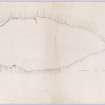
The face of the country in the area E of Lochwinnoch and S of Kilbarchan is characterised by numerous isolated outcrops and by irregular hills and knolls the flanks of many which are rocky and precipitous One of the most conspicuous of these is Walls Hill, a flattish, oval feature which lies between North Castlewalls farmhouse and the ruined steading of South Castlewalls. The summit area, which attains a height of 750 feet O. D., measures about 1,600 feet from N to S by about 700 feet transversely. It is bordered for the most part by steep rocky slopes and cliffs between 20 feet and 30 feet in height, except in the SW where it is connected to the adjacent land by a slight grass-covered slope. The remains of a rampart border most of the N end of the plateau and can be traced in places along the N parts of the E and W sides. They probably represent the remains of a continuous rampart which originally bordered the whole of the plateau. The S half of the latter is comparatively level and has been under intensive cultivation, while parts of the N half, which is more uneven, have been ploughed and drained. It is difficult, however, to see how these processes could have destroyed much of a rampart which, for most of its length, ran along the brink of steep slopes and cliffs and would, indeed, have served as a field boundary. Its absence for so much of the presumed course must rather be due to the natural effects of erosion and collapse and to robbing.
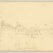
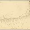
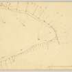
Along the N end of the summit plateau the rampart consists of a grass-covered, stony mound spread as much as 17 feet in width. The height from the inner bottom to the crest is only a few inches, but that from the outer bottom is up to 2 feet. At half a dozen places rocky ridges which lay on the course of the rampart have been quarried away both to admit the rampart and to provide material for it. This work is on a considerable scale. An entrance through the W part of the N sector consists of a gap in the rampart 20 feet in width through which a deep and steep hollow runs up from the slope side to enter for a distance of 30 feet into the enclosure. The rampart is breached again at a point 200 feet to the E by a modern agricultural track which rises slowly upwards across the N face of the hill, crosses the rampart obliquely and carries on for some distance between the latter and the quarried rock which here lies parallel to it for a distance of 200 feet.
If it is assumed that the whole of the summit area was originally enclosed by the rampart, the structure thus formed would be the largest hill-fort in the district. It might have been expected that, in spite of cultivation and the presence of coarse grass and heather some traces of internal structures would be visible, especially as considerable parts of the surface of the N part of the plateau are sufficiently irregular not to have been ploughed but are none the less perfectly suitable for hut sites. Although no such structures were visible on the date of visit or on the air photographs (541 A/471, 4009-10), huts have since been discovered by excavation.
The probability that the rampart was once more substantial and more extensive may be supported by the names of the hill and of the adjacent farms, North and South Castlewalls, names which would certainly not be warranted by the present remains. The situation and the extent of the existing structure (cf. NT72SE 10, Inventory of Roxburghshire No.299) justify its being described as a fort, but the possibility that it represents a town or oppidum cannot be ruled out.
NS 411 588
OS maps xi SE and xv NE (Intrenchment)
Visited by RCAHMS (RWF) 12 July 1954