Pricing Change
New pricing for orders of material from this site will come into place shortly. Charges for supply of digital images, digitisation on demand, prints and licensing will be altered.
Field Visit


Date 7 July 1954
Event ID 925519
Category Recording
Type Field Visit
Permalink http://canmore.org.uk/event/925519
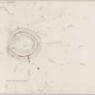
This structure is situated close to the north side of the road through North Wood at a distance of three quarters of a mile NE of Pollok House. The site lies just within the 100 feet contour and occupies the E end of an almost imperceptible ridge from which the ground slopes down gently to the N. The earthwork is oval on plan [DP 149879] and measures 100 feet from WSW to ESE by 85 feet transversely within a ditch with an earthen bank on either side. The main feature of the defences appears to be the ditch, the bottom of the WSW arc of which is 17 feet in width and lies at a depth of 5 feet 6 inches below the crests of the banks on either side. A modern drainage trench 2 feet in width runs round the whole length of the bottom of the ditch and an outlet for the water thus collected has been cut through the N arc of the outer bank. Un t i l this breach was made the ditch must have been a wet moat. The banks are now slight and intermittent, the remaining stretches rising to a height of only a few inches above ground level and being spread to a width of up to 27 feet. The entrance, in the ESE arc, is formed by a broad causeway through the ditch. The inner and outer banks united round the heads of the ditch on either side of the causeway to leave a gap between them which must originally have measured about 10 feet in width. The whole structure is planted with trees and bushes, and the interior is featureless.
Visited by RCAHMS (RWF) 7 July 1954.