Field Visit


Date 1957
Event ID 924931
Category Recording
Type Field Visit
Permalink http://canmore.org.uk/event/924931
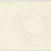
Fort, Tor Hill
This fort is situated on a low knoll which stands above the left bank of the Moness Burn in the southern outskirts of Aberfeldy at a distance of a quarter of a mile from the right bank of the River Tay. It stands at a height of 400 feet O. D. and 100 feet above the river. The structure, which is very denuded, was covered at the date of visit with conifers. Its position so near the town has doubtless led to the robbing of any stones that may originally have appeared in the ramparts while the appearance of the interior suggests that later buildings have at one time been placed within it. The fort is irregular shape on plan, with a maximum length of 150 feet from N to S by 135 feet transversely, within a rampart most of which is represented by a mere scarp. In the S arc, however, a low mound, spread to a width of 18 feet, still survives. The second rampart springs from the N arc of the first and runs thence W, S and E to die out on the E side of the knoll. There is no obvious point at which this rampart may have rejoined the NE arc of the inner one, though it may well have done so. The E arc of the outer rampart is also missing, but the rest of it remains in the form of a scarp round the other three sides of the fort. The eccentricity of the inner and median ramparts may be due to the configuration of the knoll, extra space being achieved on the summit by running the two together round the NE. corner. But the lack remains in the E must render full interpretation of the structure impossible. Otherwise the fort presents a generally similar appearance to that on Craig a' Ghuibhais.
NN 854487
Visited by RCAHMS 1957