Pricing Change
New pricing for orders of material from this site will come into place shortly. Charges for supply of digital images, digitisation on demand, prints and licensing will be altered.
Field Visit
Date 2 May 1958
Event ID 924930
Category Recording
Type Field Visit
Permalink http://canmore.org.uk/event/924930
Dun and motte, Ardclune
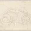
These structures are situated on a ridge which runs parallel to and 220 yards N of the left bank of the River Garry at a point a little under half a mile of Aldclune. The ridge, which at the date of visit, was covered with an open plantation of mixed trees, stands to a height of [ ] feet above sea level and [ ] feet above the river. The land to the N rises only gradually, so that the crest of the ridge commands a clear view in all directions. The topography of the ridge requires to be described so that the siting of the two structures can be understood. The N part is terminated by an almost conical mound about 60 feet in diameter at the top, from the S of which the very narrow spine the ridge runs S, rising slightly for about 100 feet. The spine then turns sharply to the E and runs down gently for another 100 feet before turning N again to die out eventually at the E foot of the conical mound. As a result of this curious conformation a steep-sided oval depression is formed at the SE. foot of the mound. Immediately S of this complex a narrow, flat area runs athwart the ridge, sloping down to the E, and thereafter comes the southernmost feature of the summit, a mound about 100 feet in diameter. Beyond this the ridge tails off and slopes away to the S. The W flank of the ridge, which borders the N mound, the central spine of the S mound, is one continuous regular slope about 500 feet in length which falls at an angle of 45 degrees to the crown below.
The N structure is formed by the adaption of the N mound, the level top of which is almost circular on plan, measuring 60 feet from N to S. While steep slopes fall 46 feet to the W, 30 feet to the N and 22 feet to the E, a narrowing neck with steep flanks joins it to the spine, a slight scarp continuing the line of the rim across the base of the neck. The neck soon narrows to a width of only 6 feet, and runs for 40 feet to the S before attaining a width of 10 feet. The remains of outer defences lie on the slopes which flank this long thin neck, those on the slope consisting of two ditches which flank a low mound, all three elements running for a distance of 35 feet down the slope before fading out. On the E slope a similar arrangement, with three ditches and two banks, runs down for 70 feet to the oval depression to which reference has been made. Two additional outer defences remain to be noted. A bank about 50 feet in length outside a terrace or quarry ditch about 70 feet in length, lies at the E foot of the mound to block access thereto from the termination of the low level hooked spine described above. A similar bank, 85 feet in length, crosses the N flank of the mound to impede access from that direction. Nothing is known about this earthwork, but its situation and design are unlike those of any known prehistoric structure. The characteristics observed however recall in some respects those of the twelfth century motte at Riddell, in Roxburghshire (Inv. 534), while the lack of any visible defence round the rim of the summit enhances the possibility that this structure too is a motte.
The S structure occupies the S mound. The central feature is an enclosure about 45 feet in diameter formed by a stony mound now about one foot in height, measured from the inner side, and 4 feet from the outside, which is spread to a thickness of about 30 feet. Stones and boulders protrude from the mound, and an angular robber trench mutilates its N arc, and there is a strong possibility that the mound represents a ruined stone wall. The original width of the wall was probably not more than 15 feet, and the original enclosure might therefore have been as much as 50 feet in diameter. A ditch lies outside the ruin of the wall, bordered on its outer side by a stony rampart. In the E and SW arcs the ditch appears as a terrace and the banks a mere crest. While no entrance is visible in the ruin of the inner wall it is probable that it would have been in the NW arc, conforming to those in the ditch and bank. Outside the bank a second ditch, with a slight bank on its outer lip, crosses the ridge from E to W, stopping on the crest of the ridge to low access to the entrances of the inner works. The only other defence is a ditch which crosses the diminishing S tail of the ridge immediately S of the main structure. The ruinous state of this structure tends to increase the difficulty of identification, in that it denies a proper understanding of the main, inner, wall. But there is nothing in the situation and character of the remains to suggest that they could not be such as a small fort or dun. None of a precisely similar nature occur in the vicinity, but examples can be sited from elsewhere eg Pittodrie, Aberdeenshire: but more likely to be a local-type dun.
If the identifications of the two structures are broadly correct, it may be assumed that the S structure was ruinous and long abandoned when the N structure was built.
NN 895 643
Visited by RCAHMS (RWF) 2 May 1958.


