Pricing Change
New pricing for orders of material from this site will come into place shortly. Charges for supply of digital images, digitisation on demand, prints and licensing will be altered.
Upcoming Maintenance
Please be advised that this website will undergo scheduled maintenance on the following dates:
Thursday, 9 January: 11:00 AM - 3:00 PM
Thursday, 23 January: 11:00 AM - 3:00 PM
Thursday, 30 January: 11:00 AM - 3:00 PM
During these times, some functionality such as image purchasing may be temporarily unavailable. We apologise for any inconvenience this may cause.
Field Visit
Date 11 November 1976
Event ID 581498
Category Recording
Type Field Visit
Permalink http://canmore.org.uk/event/581498
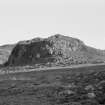
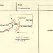
Centred NS 0865 5330 There is little surface evidence of the early occupation revealed by excavation at Little Dunagoil (Marshall 1964) (name accepted locally); a short stretch of walling, now reduced to a grass-covered spread of stones 1.5m wide, on the S side of the summit and a length of walling (kk on plan) (Marshall 1964) are all that can be traced. The latter leads down from the top of the site and runs alongside another much ruined wall 4.0m away on its N to form an entrance passage at the only point of easy access to the fort. Just to the N of this entrance is the enclosure 'C', bounded by steep slopes on all sides except the W where there is a well-preserved wall ('Y' on plan) 1.5m wide and 0.6m high. Wall '00' runs down the slope from here to a point just behind the eastern longhouse. The two longhouses are generally as described. A turf and stone wall 2.0m wide and 0.8m high runs around the east side of the hill to partially enclose the whole complex. It has been destroyed by a modern field wall on the N but reappears just to the W where it is accompanied for a short distance by an outer bank. This turf wall also runs southwards from Little Dunagoil for about 300.0m and appears to enclose all the land on its seaward side, and though described as a rampart by the previous authority it would seem to be of a defining or confining nature rather then defensive.
At NS 0861 5333 under the W facing cliff is a cave (F on plan) 2.0m high by 1.5m wide by 5.0 long. The finds from this site are in Rothesay Museum.
Surveyed at 1:10 000.
Visited by OS (B S) 11 November 1976.


