Pricing Change
New pricing for orders of material from this site will come into place shortly. Charges for supply of digital images, digitisation on demand, prints and licensing will be altered.
Upcoming Maintenance
Please be advised that this website will undergo scheduled maintenance on the following dates:
Thursday, 9 January: 11:00 AM - 3:00 PM
Thursday, 23 January: 11:00 AM - 3:00 PM
Thursday, 30 January: 11:00 AM - 3:00 PM
During these times, some functionality such as image purchasing may be temporarily unavailable. We apologise for any inconvenience this may cause.
Field Visit


Date 20 March 2009
Event ID 581460
Category Recording
Type Field Visit
Permalink http://canmore.org.uk/event/581460
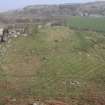
This fort is situated on a volcanic plug in rough ground about 400m SW of Dunagoil farmstead (NS05SE 44) and about 300m NE of the more substantial vitrified fort at Dunagoil (NS05SE 4). The enclosed area measures about 75m from SW to NE by 20m and is shaped in plan like a dumbell, slightly enlarged at the SW end. There are three flattish areas in the interior, which were excavated by D N Marshall between 1958 and 1962; two at the SW (Areas A and B) and one lower area at the NE (Area C), connected by a narrower section sloping from NW to SE. The edges of the volcanic plug are less precipitous to the S and SE and it is here that the best preserved sections of rampart survive, though it is visible at other points round the circumference. A later, better preserved and narrower bank straddles the interior cutting off area C. Blain, writing in the early 19th century, mentions the 'Little Dun' describing the mixture of natural and artificial dykes and excavations, and supposing that it was probably an outwork to Dunagoil (1880, 79).
The adjacent farmstead, possibly occupied in the Norse period, is considered elsewhere (NS05SE 30).
Visited by RCAHMS (GFG, AGCH, ARG, IP) 20 March 2009.