
RCAHMS Archaeological Field Survey, Eigg


Date 2001 - 2002
Event ID 571149
Category Project
Type Project
Permalink http://canmore.org.uk/event/571149
The archaeological survey of Eigg was undertaken by RCAHMS between April 2001 and February 2003. It involved the dGPS mapping of 1163 individual structures, the detailed characteristics of which were recorded in a database (DT000124). Additional features such as the remains of cultivation, clearance cairns and field banks were recorded by dGPS or transcribed from vertical aerial photographs. Some 19 detailed surveys were undertaken of individual sites.
Brief mention of the project was made in Discovery and Excavation in Scotland (2002, 126) while a summary of the archaeology of Eigg was prepared for a field excursion by Commissioners in September 2002 (WP004479). The results of the survey, and in particular a map of the island’s archaeology, were published in 2003 (WP003851). Along with the surveys of the island of Canna (1994-5), Muck (2002) and part of Rum (2011) the results of this survey were given wider analysis in Professor John Hunter’s ‘The Small Isles’, published by Historic Environment Scotland in 2016.
Final entry of data into the Canmore website, and the creation of site-area polygons, took place in 2017.
Information from HES Survey and Recording (GFG) June 2017

| Event | Type | Subtype | Notes | Date |
|---|---|---|---|---|
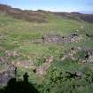
| 1019201 | RECORDING | FIELD VISIT | There are the remains of four or five enclosures at the NE edge of the enclosed ground some 330m N of Five Pennies township (NM48NE 39). The site was previously recorded as a settlement (Cushion 1996/7, Site 1) [...] | 15 May 1991 |
| 697791 | RECORDING | FIELD VISIT | NM48SE 63 48795 82898. [...] | 23 April 2001 |
| 609632 | RECORDING | FIELD VISIT | NM 48706 83193. The grassy terraces of the central and southern parts of Eilean Chathastail bear extensive traces of lazy-bed cultivation in numerous small patches, amounting to at least 8ha in all. Within this area (though mainly clustered close to the centre of the island) there are at least twelve small shieling huts, two enclosures and two small pens. There are also numerous clearance cairns around and amongst the lazy-beds. [...] | 23 April 2001 |

SC 667172
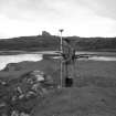
Julie Candy (RCAHMS) operating GNSS survey equipment on Eigg.
Records of the Royal Commission on the Ancient and Historical Monuments of Scotland (RCAHMS), Edinbu
6/2001
© Crown Copyright: HES

SC 686860
View of the fort, Poll Duchaill, Eigg, with the hills of Rhum in the background.
Records of the Royal Commission on the Ancient and Historical Monuments of Scotland (RCAHMS), Edinbu
2001
© Crown Copyright: HES

SC 686861
Eigg, Laig, view of square cairn cemetery. Digital image of slide.
Records of the Royal Commission on the Ancient and Historical Monuments of Scotland (RCAHMS), Edinbu
2001
© Crown Copyright: HES

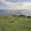
SC 722842
General view of Rubh' an Tangaird centred on a structure, taken from the NNW.
Records of the Royal Commission on the Ancient and Historical Monuments of Scotland (RCAHMS), Edinbu
18/6/2001
© Crown Copyright: HES

SC 729705
Copy of colour photograph showing Kildonan Mill, Isle of Eigg.
Records of the Royal Commission on the Ancient and Historical Monuments of Scotland (RCAHMS), Edinbu
2001
© Crown Copyright: HES

SC 729709
Copy of colour photograph showing Laig farmhouse and Cleadale, Isle of Eigg from S.
Records of the Royal Commission on the Ancient and Historical Monuments of Scotland (RCAHMS), Edinbu
2001
© Crown Copyright: HES

SC 729710
Copy of colour photograph showing Laig farmhouse, Isle of Eigg.
Records of the Royal Commission on the Ancient and Historical Monuments of Scotland (RCAHMS), Edinbu
c. 2001
© Crown Copyright: HES

SC 729711
Copy of colour photograph showing Kildonnan farmhouse, Isle of Eigg.
Records of the Royal Commission on the Ancient and Historical Monuments of Scotland (RCAHMS), Edinbu
2001
© Crown Copyright: HES

SC 729713
Copy of colour photograph showing fort on Rubha na Crannaig, Isle of Eigg.
Records of the Royal Commission on the Ancient and Historical Monuments of Scotland (RCAHMS), Edinbu
2001
© Crown Copyright: HES

SC 729717
Copy of colour photograph showing the level terrace at the entrance to the possible ritual enclosure at Sron na h-Iolaire, Isle of Eigg.
Records of the Royal Commission on the Ancient and Historical Monuments of Scotland (RCAHMS), Edinbu
2001
© Crown Copyright: HES

SC 729720
Copy of colour slide showing dun on Loch nam Ban Mora with An Sgurr beyond. View from NW. Digital Image only.
Records of the Royal Commission on the Ancient and Historical Monuments of Scotland (RCAHMS), Edinbu
2001
© Crown Copyright: HES

SC 729721
Copy of colour slide showing the Glebe Barn, by the manse, Isle of Eigg. Digital Image only.
Records of the Royal Commission on the Ancient and Historical Monuments of Scotland (RCAHMS), Edinbu
2001
© Crown Copyright: HES

SC 729722
Eigg, Five Pennies, Township and Field System. View of building (EIGG01 305) from N.
Records of the Royal Commission on the Ancient and Historical Monuments of Scotland (RCAHMS), Edinbu
4/2001
© Crown Copyright: HES

SC 729724
RCAHMS survey drawing, plan and detail: shieling-hut at Bidein an Tighearne, Isle of Eigg.
Records of the Royal Commission on the Ancient and Historical Monuments of Scotland (RCAHMS), Edinbu
6/9/2001
© Crown Copyright: HES

SC 729725
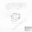
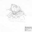
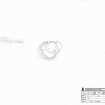
RCAHMS survey drawing; plan of Galmisdale dun, Isle of Eigg.
Records of the Royal Commission on the Ancient and Historical Monuments of Scotland (RCAHMS), Edinbu
6/9/2001
© Crown Copyright: HES

SC 729726
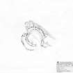
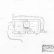
RCAHMS survey drawing; plan of fort, Kildonnan.
Records of the Royal Commission on the Ancient and Historical Monuments of Scotland (RCAHMS), Edinbu
30/8/2001
© Crown Copyright: HES

SC 729727
RCAHMS survey drawing; plan of possible house at Rubh' an Tangaird, Isle of Eigg.
Records of the Royal Commission on the Ancient and Historical Monuments of Scotland (RCAHMS), Edinbu
29/8/2001
© Crown Copyright: HES

SC 729728
RCAHMS survey drawing; plan of hut-circle at Howlin, Isle of Eigg.
Records of the Royal Commission on the Ancient and Historical Monuments of Scotland (RCAHMS), Edinbu
30/8/2001
© Crown Copyright: HES

SC 729732
RCAHMS survey drawing; Plan of possible ritual enclosure (the Oracle) at Sron na h-Iolaire, Isle of Eigg.
Records of the Royal Commission on the Ancient and Historical Monuments of Scotland (RCAHMS), Edinbu
4/9/2001
© Crown Copyright: HES

SC 730446
RCAHMS survey drawing; square cairn cemetery, Laig, Eigg.
Records of the Royal Commission on the Ancient and Historical Monuments of Scotland (RCAHMS), Edinbu
4/2002
© Crown Copyright: HES

SC 759496
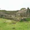
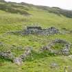
Eigg, Grulin Uachdrach, Township. View of buildings (212,213,214) from NW.
Records of the Royal Commission on the Ancient and Historical Monuments of Scotland (RCAHMS), Edinbu
31/1/2003
© Crown Copyright: HES

SC 759497
Eigg, Struidh. Rock Shelter. View of rock shelter from SE.
Records of the Royal Commission on the Ancient and Historical Monuments of Scotland (RCAHMS), Edinbu
17/4/2002
© Crown Copyright: HES

SC 759498
Eigg, Clach Alasdair. View of kelp-kiln from SE.
Records of the Royal Commission on the Ancient and Historical Monuments of Scotland (RCAHMS), Edinbu
9/2001
© Crown Copyright: HES

SC 771459
General view of building from N.
Records of the Royal Commission on the Ancient and Historical Monuments of Scotland (RCAHMS), Edinbu
c. 2001
© Crown Copyright: HES

SC 771464
General view of building from N.
Records of the Royal Commission on the Ancient and Historical Monuments of Scotland (RCAHMS), Edinbu
c. 2001
© Crown Copyright: HES

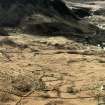
SC 771465
View of lazy beds from SE.
Records of the Royal Commission on the Ancient and Historical Monuments of Scotland (RCAHMS), Edinbu
c. 2001
© Crown Copyright: HES

SC 771497
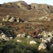
Eigg, Grulin Uachdrach, Township. View of building (EIGG01 210) from SW.
Records of the Royal Commission on the Ancient and Historical Monuments of Scotland (RCAHMS), Edinbu
10/2002
© Crown Copyright: HES

SC 771498
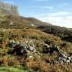
Eigg, Grulin Uachdrach, Township. View of building from SW.
Records of the Royal Commission on the Ancient and Historical Monuments of Scotland (RCAHMS), Edinbu
10/2002
© Crown Copyright: HES

SC 771499
Eigg, Cleadale, Township. View of croft boundaries at N end of Cleadale township from W.
Records of the Royal Commission on the Ancient and Historical Monuments of Scotland (RCAHMS), Edinbu
2001
© Crown Copyright: HES

SC 771503
View of croft boundaries and earlier field-system from cliffs to N of Cleadale, Eigg.
Records of the Royal Commission on the Ancient and Historical Monuments of Scotland (RCAHMS), Edinbu
5/2001
© Crown Copyright: HES

SC 771504
Eigg, Five Pennies, Township and Field System. View of building (EIGG01 305) from N.
Records of the Royal Commission on the Ancient and Historical Monuments of Scotland (RCAHMS), Edinbu
4/2001
© Crown Copyright: HES

SC 771507
Eigg, Corragan Mor. View of fort from S.
Records of the Royal Commission on the Ancient and Historical Monuments of Scotland (RCAHMS), Edinbu
10/2002
© Crown Copyright: HES

SC 771508
Eigg, Manse Wood, Hit-Circle. View of hut-circle from N.
Records of the Royal Commission on the Ancient and Historical Monuments of Scotland (RCAHMS), Edinbu
6/2001
© Crown Copyright: HES

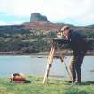
SC 774901
Alan Leith (RCAHMS) using a Wild Self-reducing alidade and plane-table during an archaeological survey.
Records of the Royal Commission on the Ancient and Historical Monuments of Scotland (RCAHMS), Edinbu
2001
© Crown Copyright: HES

SC 774931
Robert Adam (RCAHMS) taking a survey photograph, with Dave Cowley in the background. DIGITAL IMAGE ONLY
Records of the Royal Commission on the Ancient and Historical Monuments of Scotland (RCAHMS), Edinbu
2001
© Crown Copyright: HES

SC 857941
Eigg, Struidh, Ritual Enclosure. View of entrance into a void in the boulder field, adjacent to the ritual enclosure.
Records of the Royal Commission on the Ancient and Historical Monuments of Scotland (RCAHMS), Edinbu
2001
© Crown Copyright: HES

SC 883707
Copy of colour slide showing dun on Loch nam Ban Mora, Isle of Eigg. Digital Image only.
Records of the Royal Commission on the Ancient and Historical Monuments of Scotland (RCAHMS), Edinbu
2001
© Crown Copyright: HES

SC 1322440
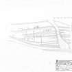
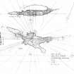
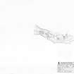
RCAHMS survey drawing; plan of Clanranald harbour.
Records of the Royal Commission on the Ancient and Historical Monuments of Scotland (RCAHMS), Edinbu
24/4/2002
© Crown Copyright: HES

SC 1348621
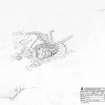
RCAHMS survey drawing; plan of Poll Duchaill fort.
Records of the Royal Commission on the Ancient and Historical Monuments of Scotland (RCAHMS), Edinbu
31/8/2001
© Crown Copyright: HES

SC 1348644
RCAHMS Survey drawing; plan of hut-circles at Cnoc Smeordail
Records of the Royal Commission on the Ancient and Historical Monuments of Scotland (RCAHMS), Edinbu
2/9/2001
© Crown Copyright: HES

SC 1348648
RCAHMS Survey drawing; plan and sections, underground structure at Struidh.
Records of the Royal Commission on the Ancient and Historical Monuments of Scotland (RCAHMS), Edinbu
4/9/2001
© Crown Copyright: HES

SC 1348658
RCAHMS survey drawing; plan of square cairns at Laig.
Records of the Royal Commission on the Ancient and Historical Monuments of Scotland (RCAHMS), Edinbu
6/9/2001
© Crown Copyright: HES

SC 1348659
RCAHMS survey drawing; plan of shieling group at Bidein An Tighearna
Records of the Royal Commission on the Ancient and Historical Monuments of Scotland (RCAHMS), Edinbu
24/4/2002
© Crown Copyright: HES

SC 1348662
RCAHMS survey drawing; plan of southern shieling group at Lochan Nighean Dughaill
Records of the Royal Commission on the Ancient and Historical Monuments of Scotland (RCAHMS), Edinbu
20/4/2002
© Crown Copyright: HES

SC 1348663
RCAHMS survey drawing; plan of Garbh Bealach fort
Records of the Royal Commission on the Ancient and Historical Monuments of Scotland (RCAHMS), Edinbu
13/10/2002
© Crown Copyright: HES

SC 1348664
RCAHMS survey drawing; plan of fort at Corragan Mor.
Records of the Royal Commission on the Ancient and Historical Monuments of Scotland (RCAHMS), Edinbu
12/10/2002
© Crown Copyright: HES

SC 1348665
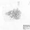
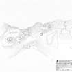
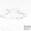
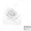
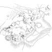
RCAHMS survey drawing; plan of township at Grulin.
Records of the Royal Commission on the Ancient and Historical Monuments of Scotland (RCAHMS), Edinbu
15/10/2002
© Crown Copyright: HES

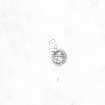
SC 1348666
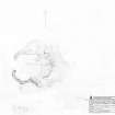
RCAHMS survey drawing; plan of dun at Grulin
Records of the Royal Commission on the Ancient and Historical Monuments of Scotland (RCAHMS), Edinbu
15/10/2002
© Crown Copyright: HES

SC 1348667
Survey drawing; plan of chapel at Kildonnan
Records of the Royal Commission on the Ancient and Historical Monuments of Scotland (RCAHMS), Edinbu
7/7/1998
© Crown Copyright: HES

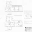
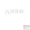
SC 1348668
Survey drawing; ground plan and elevation of house at Sandavore
Records of the Royal Commission on the Ancient and Historical Monuments of Scotland (RCAHMS), Edinbu
8/7/1998
© Crown Copyright: HES

SC 1348669
Survey drawing; plan of house at Galmisdale
Records of the Royal Commission on the Ancient and Historical Monuments of Scotland (RCAHMS), Edinbu
7/1998
© Crown Copyright: HES

SC 1348670
RCAHMS survey drawing; plan of crofthouse at Cleadale
Records of the Royal Commission on the Ancient and Historical Monuments of Scotland (RCAHMS), Edinbu
7/9/2001
© Crown Copyright: HES

SC 1472613
RCAHMS publication drawing; plan and elevation of shieling-hut at Bidein an Tighearne.
Records of the Royal Commission on the Ancient and Historical Monuments of Scotland (RCAHMS), Edinbu
11/3/2003
© Crown Copyright: HES

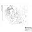
SC 1472614
RCAHMS publication drawing; plan of Grulin township. North to top.
Records of the Royal Commission on the Ancient and Historical Monuments of Scotland (RCAHMS), Edinbu
20/3/2003
© Crown Copyright: HES

SC 1472615
RCAHMS inked drawing; plan of fort, Poll Duchaill
Records of the Royal Commission on the Ancient and Historical Monuments of Scotland (RCAHMS), Edinbu
17/3/2003
© Crown Copyright: HES

SC 1472616
RCAHMS inked drawing; plan of hut circles, Cnoc Smeordail.
Records of the Royal Commission on the Ancient and Historical Monuments of Scotland (RCAHMS), Edinbu
17/3/2003
© Crown Copyright: HES

SC 1472642
RCAHMS inked drawing; plan of possible house at Rubh' an Tangaird
Records of the Royal Commission on the Ancient and Historical Monuments of Scotland (RCAHMS), Edinbu
21/3/2003
© Crown Copyright: HES

SC 1472643
RCAHMS publication drawing; ground plan of ritual enclosure.
Records of the Royal Commission on the Ancient and Historical Monuments of Scotland (RCAHMS), Edinbu
26/3/2003
© Crown Copyright: HES

SC 1472644
RCAHMS survey drawing; plan of square cairns at Laig.
Records of the Royal Commission on the Ancient and Historical Monuments of Scotland (RCAHMS), Edinbu
6/9/2001
© Crown Copyright: HES

SC 1523859
Eigg, Struidh, Ritual Enclosure. Ian Parker undertaking a plane table survey of 'The Oracle' chamber.
Records of the Royal Commission on the Ancient and Historical Monuments of Scotland (RCAHMS), Edinbu
2001
© Crown Copyright: HES

SC 1523860
Eigg, Struidh, Ritual Enclosure. Ian Parker undertaking a plane table survey of 'The Oracle' chamber.
Records of the Royal Commission on the Ancient and Historical Monuments of Scotland (RCAHMS), Edinbu
2001
© Crown Copyright: HES

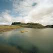
SC 1524971
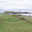
Eigg, Poll Duchaill, Fort. View from W.
Records of the Royal Commission on the Ancient and Historical Monuments of Scotland (RCAHMS), Edinbu
2001
© Crown Copyright: HES

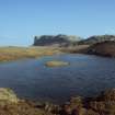
SC 1524993
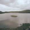
Eigg, Loch nam Ban Mora, Dun. View from NW.
Records of the Royal Commission on the Ancient and Historical Monuments of Scotland (RCAHMS), Edinbu
2001
© Crown Copyright: HES

SC 1524994
Eigg, Struidh, Ritual Enclosure. View from W.
Records of the Royal Commission on the Ancient and Historical Monuments of Scotland (RCAHMS), Edinbu
2001
© Crown Copyright: HES

SC 1544524
Eigg, Struidh, Ritual Enclosure. View of ritual enclosure from SW.
Records of the Royal Commission on the Ancient and Historical Monuments of Scotland (RCAHMS), Edinbu
2001
© Crown Copyright: HES

SC 1544525
Eigg, Struidh, Ritual Enclosure. View of ritual enclosure from SW.
Records of the Royal Commission on the Ancient and Historical Monuments of Scotland (RCAHMS), Edinbu
2001
© Crown Copyright: HES

SC 1544526
Eigg, Struidh, Ritual Enclosure. View of chamber entrance.
Records of the Royal Commission on the Ancient and Historical Monuments of Scotland (RCAHMS), Edinbu
2001
© Crown Copyright: HES

SC 1544527
Eigg, Struidh, Ritual Enclosure. View of chamber interior.
Records of the Royal Commission on the Ancient and Historical Monuments of Scotland (RCAHMS), Edinbu
2001
© Crown Copyright: HES

SC 1544528
Eigg, Struidh, Ritual Enclosure. View from W.
Records of the Royal Commission on the Ancient and Historical Monuments of Scotland (RCAHMS), Edinbu
2001
© Crown Copyright: HES

SC 1544529
Eigg, Struidh, Ritual Enclosure. View from W.
Records of the Royal Commission on the Ancient and Historical Monuments of Scotland (RCAHMS), Edinbu
2001
© Crown Copyright: HES

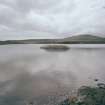
SC 1544530
Eigg, Loch nam Ban Mora, Dun. View from NE.
Records of the Royal Commission on the Ancient and Historical Monuments of Scotland (RCAHMS), Edinbu
6/2001
© Crown Copyright: HES

SC 1544531
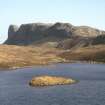
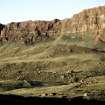
Eigg, An Sgurr, Fort. View of wall from W.
Records of the Royal Commission on the Ancient and Historical Monuments of Scotland (RCAHMS), Edinbu
6/2001
© Crown Copyright: HES

SC 1544532
Eigg, An Sgurr, Fort. View of wall from W.
Records of the Royal Commission on the Ancient and Historical Monuments of Scotland (RCAHMS), Edinbu
6/2001
© Crown Copyright: HES

SC 1544533
Eigg, Loch nam Ban Mora, Dun. View from NE.
Records of the Royal Commission on the Ancient and Historical Monuments of Scotland (RCAHMS), Edinbu
6/2001
© Crown Copyright: HES

SC 1544534
Eigg, Galmisdale Pier, Dun. View from SW.
Records of the Royal Commission on the Ancient and Historical Monuments of Scotland (RCAHMS), Edinbu
2001
© Crown Copyright: HES

SC 1544535
Eigg, Galmisdale Pier, Dun. View from NW.
Records of the Royal Commission on the Ancient and Historical Monuments of Scotland (RCAHMS), Edinbu
2001
© Crown Copyright: HES

SC 1544536
Neolithic House. View from E.
Records of the Royal Commission on the Ancient and Historical Monuments of Scotland (RCAHMS), Edinbu
2001
© Crown Copyright: HES

SC 1544537
View from N.
Records of the Royal Commission on the Ancient and Historical Monuments of Scotland (RCAHMS), Edinbu
2001
© Crown Copyright: HES

SC 1544538
View from N.
Records of the Royal Commission on the Ancient and Historical Monuments of Scotland (RCAHMS), Edinbu
2001
© Crown Copyright: HES

SC 1544539
Eigg, Grulin Uachdrach township, view from N.
Records of the Royal Commission on the Ancient and Historical Monuments of Scotland (RCAHMS), Edinbu
2001
© Crown Copyright: HES

SC 1544540
Eigg, Grulin Uachdrach township, view from N.
Records of the Royal Commission on the Ancient and Historical Monuments of Scotland (RCAHMS), Edinbu
2001
© Crown Copyright: HES

SC 1544592
Eigg, Grulin Uachdrach. View of township from An Sgurr.
Records of the Royal Commission on the Ancient and Historical Monuments of Scotland (RCAHMS), Edinbu
2001
© Crown Copyright: HES

SC 1544593
Eigg, Galmisdale, Metal Working Site. Excavation of possible metal working site.
Records of the Royal Commission on the Ancient and Historical Monuments of Scotland (RCAHMS), Edinbu
2001
© Crown Copyright: HES

SC 1544594
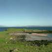
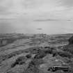
View of Rum taken from Poll Duchaill, Eigg.
Records of the Royal Commission on the Ancient and Historical Monuments of Scotland (RCAHMS), Edinbu
2001
© Crown Copyright: HES

SC 1544595
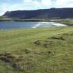
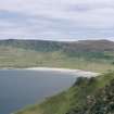
Eigg, Cleadale, Township. View of Cleadale from Poll Duchaill.
Records of the Royal Commission on the Ancient and Historical Monuments of Scotland (RCAHMS), Edinbu
2001
© Crown Copyright: HES

SC 1544596
Eigg, Galmisdale Bay. View of fishtrap with pier in the background.
Records of the Royal Commission on the Ancient and Historical Monuments of Scotland (RCAHMS), Edinbu
2001
© Crown Copyright: HES

SC 1544597
Eigg, An Sgurr, Fort. View from Kildonnan.
Records of the Royal Commission on the Ancient and Historical Monuments of Scotland (RCAHMS), Edinbu
2001
© Crown Copyright: HES

SC 1544598
Eigg, An Sgurr, Fort. View from Kildonnan.
Records of the Royal Commission on the Ancient and Historical Monuments of Scotland (RCAHMS), Edinbu
2001
© Crown Copyright: HES

SC 1544599
Eigg, An Sgurr, Fort. View from Kildonnan.
Records of the Royal Commission on the Ancient and Historical Monuments of Scotland (RCAHMS), Edinbu
2001
© Crown Copyright: HES

SC 1544600
Eigg, An Sgurr, Fort. View from Kildonnan.
Records of the Royal Commission on the Ancient and Historical Monuments of Scotland (RCAHMS), Edinbu
2001
© Crown Copyright: HES

SC 1544601
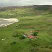
Eigg, Laig, Laig Farm. View from SW.
Records of the Royal Commission on the Ancient and Historical Monuments of Scotland (RCAHMS), Edinbu
2001
© Crown Copyright: HES

SC 1544602
Eigg, Galmisdale Bay, Clanranald Harbour. View of harbour and fishtraps from N.
Records of the Royal Commission on the Ancient and Historical Monuments of Scotland (RCAHMS), Edinbu
2001
© Crown Copyright: HES

SC 1544603
Eigg, Galmisdale Bay, Clanranald Harbour. View of harbour and fishtraps from NE.
Records of the Royal Commission on the Ancient and Historical Monuments of Scotland (RCAHMS), Edinbu
2001
© Crown Copyright: HES

SC 1544604
Eigg, Galmisdale Bay, Clanranald Harbour. View of and fishtraps from harbour.
Records of the Royal Commission on the Ancient and Historical Monuments of Scotland (RCAHMS), Edinbu
2001
© Crown Copyright: HES

SC 1544605
Eigg, Galmisdale Bay, Clanranald Harbour. View of fishtraps and harbour from S.
Records of the Royal Commission on the Ancient and Historical Monuments of Scotland (RCAHMS), Edinbu
2001
© Crown Copyright: HES

SC 1544606
Eigg, Rubha na Crannaig, Fort. View from SE.
Records of the Royal Commission on the Ancient and Historical Monuments of Scotland (RCAHMS), Edinbu
2001
© Crown Copyright: HES

SC 1544607
Eigg, Kildonnan, Rubha na Crannaig. View from N.
Records of the Royal Commission on the Ancient and Historical Monuments of Scotland (RCAHMS), Edinbu
2001
© Crown Copyright: HES

SC 1544608
Eigg, Rubha na Crannaig, Cairns. View from SE.
Records of the Royal Commission on the Ancient and Historical Monuments of Scotland (RCAHMS), Edinbu
2001
© Crown Copyright: HES

SC 1544609
Eigg, Rubha na Crannaig, Cairns. View of interior of E cairn from NE.
Records of the Royal Commission on the Ancient and Historical Monuments of Scotland (RCAHMS), Edinbu
2001
© Crown Copyright: HES

SC 1544610
Eigg, Kildonnan, Rubha na Crannaig. View from N.
Records of the Royal Commission on the Ancient and Historical Monuments of Scotland (RCAHMS), Edinbu
2001
© Crown Copyright: HES


First 100 images shown.
Archaeological Survey of Eigg
Archaeological Survey of Eigg: survey drawings
Archaeological Survey of Eigg: photographs
