Following the launch of trove.scot in February 2025 we are now planning the retiral of some of our webservices. Canmore will be switched off on 24th June 2025. Information about the closure can be found on the HES website: Retiral of HES web services | Historic Environment Scotland
Field Visit


Date May 1968
Event ID 1175886
Category Recording
Type Field Visit
Permalink http://canmore.org.uk/event/1175886
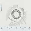
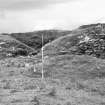
NM 867 429. Standing in a prominent position on the highest point of an elongated limestone ridge 550 m SW of Port Maluag, this broch provides a conspicuous landmark on the E side of Lismore Island (Pl. 10A, B) and is one of the best-preserved prehistoric monuments in the county. From a height of 47'9 m OD the site commands an extensive prospect in all directions, especially towards the E across the Lynn of Lorn to the mainland beyond. The NW and SE flanks of the ridge fall steeply, the latter to a gently sloping terrace about 20 m broad, whose outer limit is bounded by a precipitous cliff which rises from the shore; access to the broch is, however, comparatively easy from the NE and SW along the crest of the ridge.
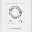
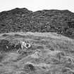
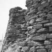
Almost circular on plan (Fig. 44), the broch is constructed, at ground-level, of a solid dry-stone wall measuring 4'5 m in average thickness, which encloses a central court about 12'2 m in diameter. Though considerably reduced by stone-robbing and collapse, the outer face of the wall (Pl. 10C) is still standing, for the most part, to a height of at least 3 m, and on the SE it rises to its maximum surviving height of 4'9 m with a uniform batter of about one in four. The footings and the first five or six courses of masonry, up to a height of about 1.5 m above ground, incorporate a considerable number of massive boulders; above this level, however, the coursing is less regular, the material used including a high proportion of thin slabs with pinnings of smaller stones.
By comparison, the inner face of the wall has suffered more severely, and the floor of the central court is buried under a mass of debris to a depth of at least I m. The best surviving portion is in the NW quadrant, where the face is exposed to a height of 3'5 m. After rising almost vertically for about 1.5 m above the present surface (i.e. about 2'5 m above the floor-level), the inner face is stepped back to form a level ledge or scarcement 0·6 m wide. At the present time the scarcement can be traced for only three-quarters of the circuit, the SE quadrant being buried under a spread of fallen stones. Above the scarcement the face continues upwards for a further 1.5 m with a batter of about one in three, the quality of the masonry being much inferior to that of the lower portion. Below the scarcement on the N, the face of the wall is interrupted by a doorway 1'0 m wide; now choked with debris, this opening probably gives access either to a mural cell or to a staircase leading upwards within the thickness of the wall.
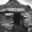
The entrance to the broch faces WSW and is 1'4 m wide at either end. The SE side-wall of the passage is straight, but the NW side is slightly concave, thus increasing the width to a maximum of 1.5 m at a point 2'7 m from its outer end. The walling at the entrance is so ruinous that no traces can be seen of door-checks, bar-holes or an entrance to a mural guard-chamber, and the floor of the passage is hidden by debris.
At a height of about 2'7 m above ground-level traces of an intramural gallery can be seen in the broch wall; it was probably continuous, but the collapse of the wall has completely destroyed it on either side of the main entrance, and elsewhere it is now more or less in a fragmentary condition. A well-preserved stretch is, however, visible for a distance of 7 m in the NW quadrant, measuring 1 m in height and 0·6 m in average breadth internally, and roofed by a series of large transverse lintels. At the open (S) end (Pl. 10D) it can be seen that the side-walls of the gallery are very unevenly finished internally and that the floor appears to be formed by the unpaved core-material of the solid broch wall below, indicating that the function of the gallery was merely structural. Another short section of the gallery, still lintelled but in a rather unstable condition, survives on the E, but elsewhere little remains visible except the outer casement, which stands to a maximum height of 0·8 m above the gallery floor. The sockets where the outer ends of lintel-stones have rested can be seen intermittently, and some of the dislodged lintels are lying embedded in the debris that now partly fills the gallery. On the NE, about 0'7 m above the level of the scarcement, the inner face of the broch wall is pierced by an opening 0'9 m wide, which appears to have served as a relieving-slit and not as a doorway.
The floor of the central court is buried under debris, and on the E, where there has been a particularly heavy collapse, a crude attempt has been made to rebuild the inner face of the wall both above and below the level of the scarcement.
On both the NE and SW sides the broch is protected by outworks consisting, in each case, of a boulder-faced rubble wall running transversely across the ridge. There is no evidence to show whether or not these walls were originally linked to form a continuous defence encircling the broch, but this seems unlikely. The NE outwork now appears as a grass-grown stony bank spread to a thickness of as much as 5.5 m and standing up to 1'5 m in height externally and 0'7 m internally. The surviving stretch of the outer face is at best 0.7 m high in three courses. At its Wend the wall has been reduced to a mere scarp and there is no indication of an entrance. The SW outwork is of similar construction and appearance, measuring 3'0 m in thickness at the base and up to 1.1 m in height externally. No inner facing-stones are visible, but the outer face survives to a height of 0.7m in two courses. There is a well-marked entrance, 1'5 m wide, situated almost in line with that of the broch. Immediately outside the SW outwork there are the stone foundations of a rectangular building of comparatively recent date, which may be contemporary with the turf-and-stone boundary dykes indicated on the plan.
RCAHMS 1975, visited May 1968.