Pricing Change
New pricing for orders of material from this site will come into place shortly. Charges for supply of digital images, digitisation on demand, prints and licensing will be altered.
Measured Survey


Date 30 January 1989
Event ID 1157499
Category Recording
Type Measured Survey
Permalink http://canmore.org.uk/event/1157499
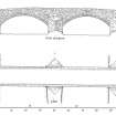
RCAHMS surveyed Bridgend Bridge, Kilmichael Glassary on 30 January 1989 producing a plan and west elevation at a scale of 1:100. The plan and elevation were redrawn in ink and published at a scale of 1:250 (RCAHMS 1992, 505B).