Measured Survey


Date 10 August 2004
Event ID 1152117
Category Recording
Type Measured Survey
Permalink http://canmore.org.uk/event/1152117
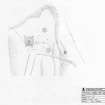
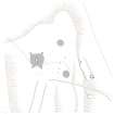
RCAHMS surveyed the chambered cairn at Cairn o'Get (ND34SW 4) on 10 August 2004 with plane table and self-reducing alidade producing a site plan of the cairn and surrounding features, including cists and cairns (ND34SW16) and a limekiln and quarries (ND34SW 397), at a scale of 1:500. The plan was later redrawn in vector graphics software, with illustrations produced at scales of 1:500 and 1:1000.