Field Visit


Date 29 May 1936
Event ID 1129185
Category Recording
Type Field Visit
Permalink http://canmore.org.uk/event/1129185
Cup-marked Rocks, Brough.
Cup markings occur in three places near the township of Brough.
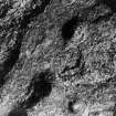
(1) [HU56NE 14] There are two groups on exposed surfaces of living rock on the E. side of the hillock, noted as a broch site [HU56NE 12 - broch site] at the N. end of the township. The upper group consists of ten much weathered cups measuring about 2 in. in average diameter and sometimes as much as 1 in. deep, spread over an area of some 18 ft. by 16 ft. The lower group comprises at least nineteen cups, spread over an area of 18 ft. by 10 ft. The cups here are from 2 ½ in. to 3 ½ in. in diameter and from 1 in. to 2 in. deep. Three of them are connected by a slight hollowing of the stone between, which gives them the appearance of a trefoil (Fig. 555 [SH 18]). One isolated cup was found some 70 yds. S. of these.
(2) [HU56SE 10] About 250 yds. S. of No. 1343, on. the E. side of the road and about 80 yds. S.W. of Houll, are three other groups on the tops of rocky outcrops. One group consists of six cups; another, some 6 ft. to the N.E., of four; and another, 35 ft. to the S., of two.
(3) A further group, situated at a place called the Steep Toons, east of Houll, was reported by a local observer, Mr. J. Stewart, after the date of visit.
The cups of all three groups are generally similar, as all are pecked out and not ground; they also seem to be similar in workmanship to those which are found on detached stones and water-worn boulders at the sites of certain brochs and other structures. They differ from these, however, in the fact that they, like many Bronze Age cup-markings, are spread over areas of living rock.
RCAHMS 1946, visited 29 May 1936.