Field Visit
Date 2 September 1920
Event ID 1114495
Category Recording
Type Field Visit
Permalink http://canmore.org.uk/event/1114495
Crichton Castle.
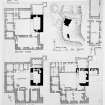
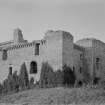
This ruined structure (Figs. 69 and 70) occupies a commanding position at the head of the river Tyne 2 ¼ miles south-west of Pathhead and about 3 miles east of Gorebridge. The site is a mass of freestone of good quality, forming a terrace just below the 600 feet contour line and projecting from higher ground on the east-all part of the plateau which here overlooks the course of the Tyne. The site is steeply scarped on the west down to a marshy haugh bordering the river; on the north, where the ground beyond the site is level therewith, an old deeply cut watercourse and a ditch intervene and render approach difficult. On the west is a ditch with an outer rampart. The buildings of the castle proper, which completely enclose a courtyard, are set at the north-west angle of the site; 41 yards to the south of these is an outbuilding, the survivor of others which were apparently scattered about the south-eastern side of the plateau. The castle buildings, still standing for a height of 50 to 60 feet above the ground, form an imposing group. The various portions have been built at different periods, but the nucleus is a late 14th-century tower in the centre of the eastern side, which is the original house and a self-contained unit. Two wings were added in the 15th century and formed the south and west sides of a courtyard, of which the northern side may have been a screen wall or another wing afterwards removed or reconstructed. The present northern range dates from the period 1581-91.
[See RCAHMS 1929 pp.47-51 for a detailed architectural description].
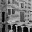
HISTORICAL NOTE. On the Crichtons of that ilk see Introd., p. xxxviii. After the forfeiture of the third lord and of a temporary holder, the property was conferred on Patrick Hepburn, Lord Hailes, who was created Earl of Bothwell. With the forfeiture of the fourth earl, Queen Mary's husband, this link was broken till restored by James VI, who conferred the lands on Bothwell's nephew, Francis Stewart, created Earl of Bothwell and Admiral of all Scotland in 1581. He had returned from Italy in 1581 and married Margaret Douglas, a daughter of the Earl of Angus, before 1 July I592. He was responsible for the building of the arcaded north wing in the Italian manner, as his initials, surmounting an anchor to signify his office of Admiral (1), with those of his wife, appear twice in monogram on the piers. Francis Stewart was forfeited in 1591, but in the reign of Charles I his son Francis was restored to the property, which he encumbered with debt, so that in 1649 it was bought by Hepburn of Humbie, from whom the castle got the local appellation of ‘Humbie's Wa's’ (2). The name suggests that in Hepburn's time the place ceased to be occupied and was neglected. With this family it remained for the next thirty vears, after which it passed through the hands of various proprietors.
RCAHMS 1929, 2 September 1920.
(1) Cf. Rae Macdonald's Scottish Armorial Seals, where his seal (1589) shows an anchor below the shield; (2) Ruined Castles of Midlothian, John Dickson, p. 242.


