Field Visit


Date 29 May 1921
Event ID 1105110
Category Recording
Type Field Visit
Permalink http://canmore.org.uk/event/1105110
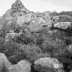
Dun Torvaig, near Portree.
On the rough northern slope of Ben Chracaig, some 7/8 mile north-east of Portree pier, at an elevation of 400 feet above sea-level, is Dun Torvaig, which occupies a rocky eminence rising about 35 feet above the surroundings, and only approachable over an ascending ridge from the south-west. The dun is oval on plan, with its main axis running almost north-west and south-east, along which it measures internally about 65 feet, while it is 48 feet in breadth. It has been defended by a stone wall encircling the summit of the ridge, with two outer walls across the approaching slope to the north west measuring from outer faces 27 feet and 10 feet apart respectively. The walls are very much dilapidated, but at the north-west end of the enceinte, where the wall has been strongest, the mass of stones remaining covers a width of 30 feet and rises about 6 feet in height; while a section of the outer face, about 9 feet in length and 3 feet in height, is still in position. The two outer walls seem to have been about 3 feet 6 inches thick. While both ends of the first wall and the southern end of the second give on to the rocky scarp on each side of the ridge, the north-eastern end of the latter returns along the edge of the ridge as far as the main wall. The entrance has been from the south-west, and it passes through the two outer walls near the southern side of the ridge, being walled on both sides between these defences and showing a width of about 3 feet 9 inches. Where it enters the inner defence is not apparent owing to the dilapidated condition of the wall.
RCAHMS 1928, visited 29 May 1921.
OS map: Skye xxiv