Following the launch of trove.scot in February 2025 we are now planning the retiral of some of our webservices. Canmore will be switched off on 24th June 2025. Information about the closure can be found on the HES website: Retiral of HES web services | Historic Environment Scotland
Field Visit


Date 31 May 1921
Event ID 1105083
Category Recording
Type Field Visit
Permalink http://canmore.org.uk/event/1105083
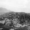
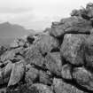
Dun, Dunan an Aisilidh, Braes.
Near the northern extremity of the peninsula terminating in the point Ardvorranish, near Braes, on the east side of the island of Skye, at the Narrows of Raasay, is an elevated flat-topped rock rising some 50 feet above the sea. On the east side is a precipice rising straight from the water. On the west, though the rocks are precipitous in places, they are of less height and the rise is more gradual, and on the south a steep-sided dry, rocky gully, above which the rock rises some 15 feet, separates it from the mainland. This rocky height is entirely occupied by the scanty remains of Dunan an Aisilidh, a fort of interesting type. While small sections of the outer foundation course and some irregular mounds of debris are all that remain on the east and north, enough of the wall remains on the south-west quadrant to indicate its dimensions and character. The dun measures internally 51 feet from east to west, and averages 50 feet from north to south, and the enclosing wall, which in general has been solid and about 7 feet thick, gradually increases to 12 feet on the south-west, where it contains a gallery now almost filled with stones. The wall here shows some 3 to 4 feet of the outer face in position, while the inner portion rises· about 4 feet above it. The entrance to the gallery from the enceinte measures 2 feet 6 inches in width, and the sides still maintain a height of about 2 feet 6 inches, while the outer lintel is still in position. It penetrates the wall for a distance of 6 feet7 inches, and the gallery then branches off towards both east and west. The eastern end extends at least 18 feet in the curve of the wall, and averages 1 foot 9 inches in width, narrowing slightly as the wall gets thinner. At the doorway the inner wall, as already stated, is 6 feet 7 inches thick, and the outer 3 feet 8 inches. At the eastern end the inner wall is 3 feet 10 inches and the outer wall 1 foot 10 inches in thickness. The outermost face of the gallery extension westwards is entirely broken down, but the inside face remaining to a height of 3 feet 6 inches for a good length can be traced definitely for a distance of some 20 feet. Seemingly the termination is about 16 feet farther on. The main entrance to the dun appears to have been in the western arc immediately to the north of the gallery end, as a hollow obscured by fallen stones traverses the wall at this part, and is continued some 11 feet into the enceinte, the southern side of this passage being flanked by what seems to be the remains of a stone wall about 2 feet high in parts. There are faint indications of a wall on the northern side also. There is no trace of an entrance at the south-eastern or landward side of the dun. Outside the supposed entrance on the west the ground is less rough than at the other parts of the surroundings, and instead of being rocky falls in a gradual grass-covered descent.
In the northern sector of the dun there is a hollow 5 feet in length and 3 feet 9 inches in breadth lined with stones, and the wall here follows the irregularities of the cliff edge.
RCAHMS 1928, visited 31 May 1921.
OS map: Skye xxxv.