Field Visit


Date 3 August 1924
Event ID 1103746
Category Recording
Type Field Visit
Permalink http://canmore.org.uk/event/1103746
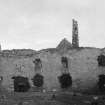
Ormaclett Castle.
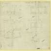
The remains of this house, a residence of the chief of Clanranald, which was built in 1701 and burnt in 1715*,are situated within a farm steading 3 ½ miles south of Howmore and 8 ½ miles north-north-west of Lochboisdale. It is two storeys and an attic in height, and is built on a T-shaped plan, with the main block, which measures 69 feet by 25 feet over all, running north-east and south-west, and the wing, 21 by 22 feet, projecting southwards. The main block is divided by a stone partition into two unequal parts, and the larger has probably been subdivided by timber partitions and provided with a wooden stair.(Fig. 155.)
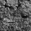
The masonry is of harled rubble with dressings of freestone, evidently imported. The gables are steeply pitched. The upper windows, which are less destroyed than those in the ground floor, have a splay wrought on jambs and lintels, the latter having slightly curved soffits. The attic was lit by dormers, now destroyed. The entrance is represented by a wide slapping in the north wall. Above is an armorial panel representing a helm, mantling and shield, the latter being parted per pale and charged in the upper dexter corner with a lion rampant above a hand couped, grasping across. The charge in the upper sinister corner is obliterated, but it may be either a burning mountain or more probably a castle, and below is a lymphad. These charges are inverted on the stone at Howmore (NF73NE 1.6).
The contiguous building on the west, comprising a single storey and a loft, contains a large kitchen fireplace with segmental arch 7 ½ feet wide.
RCAHMS 1928, visited 3 August 1924.
OS map: South Uist liii.
*Clan Donald, II., p. 344