Pricing Change
New pricing for orders of material from this site will come into place shortly. Charges for supply of digital images, digitisation on demand, prints and licensing will be altered.
Publication Account
Date 1951
Event ID 1096104
Category Descriptive Accounts
Type Publication Account
Permalink http://canmore.org.uk/event/1096104
Defensive Ramparts, King's Park.
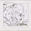
Some remains of a stone-built rampart [NT27SE 93], apparently defensive in character, run along the upper E. slopes of Arthur's Seat above the cultivation terraces ([NT27SE 76] No. 211) and, farther N., cross the best line of approach to the summit (Fig. 429A [DP 149972]). It is some 375yds. long and in parts appears to be double, but it is everywhere very much wasted. Mr. R. B. K. Stevenson, who first described the work (1), tentatively suggests a Dark Age date.
Remains of another rampart [NT27SE 38] (Fig. 429B) can also be traced for 375 yds. along the slopes W. of Hunter's Bog, while what seems to be a detached portion of it, about 100 yds. long over a gap, appears 160 yds. farther N. The Commissioners are indebted to Mr. Stevenson for having drawn their attention to these monuments, and also to [RCAHMS 1951] Nos. 209, 210 and 211.
RCAHMS 1951, visited c.1941
(1)P.S.A.S., lxxxi (1946-7), pp. 165 ff.
OS Map Midlothian iii N.E. (unnoted).


