Scheduled Maintenance
Please be advised that this website will undergo scheduled maintenance on the following dates: •
Tuesday 3rd December 11:00-15:00
During these times, some services may be temporarily unavailable. We apologise for any inconvenience this may cause.
Field Visit
Date 21 October 1908
Event ID 1088416
Category Recording
Type Field Visit
Permalink http://canmore.org.uk/event/1088416
119. Fort, Duns Law.
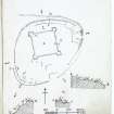
On the summit of Duns Law, to the north of the town of Duns, 700 feet above sea-level, are the partially obliterated remains of a large fortified enclosure (fig. 65 [DP 225501]) surrounded by two concentric oval ramparts and measuring some 700 feet by 550 feet over all. Towards the south the lines are effaced. In the interior there are numerous circular and irregular foundations. The entrance appears to have been from the eastwards.
A small redoubt 200 feet square with diminutive bastions at the angles, formed of earth with a small trench in front, is considered to have been thrown up by General Leslie in 1639.
Along the upper end of the field that lies below the plantation, some 375 feet to the west of the enclosure and extending for several hundred yards, is a substantial mound about 5 feet high, the object of which is not apparent.
See Antiquaries, xxix. p. 154; Ber. Nat. Club, 1892-93, p. 75.
RCAHMS 1915, visited 21st October 1908.
OS Map: Ber., xvi, NE.


