HES Kraiknish Archaeological Survey


Date 2016 - 2017
Event ID 1013793
Category Project
Type Project
Permalink http://canmore.org.uk/event/1013793
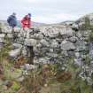
An archaeological survey of 19 square kilometres of the Kraiknish peninsula was undertaken by HES Survey and Recording in 2016 (Project ID 1282). The project, undertaken in partnership with Forestry Commission Scotland (FCS), used a high resolution Airborne Laser Scanning (ALS) dataset commissioned by FCS and gathered by Bluesky. A desk-based analysis of the area using multiple ALS-derived visualisations and other sources (historic maps, aerial photographs etc.) resulted in the identification of both known and previously unknown sites and the creation of a linework dataset. Each site was subsequently visited in the field over six days of survey between August and November 2016, and each one photographed and noted to provide a basic record. The project was undertaken by George Geddes and Dr Oscar Aldred (HES) with the help of Mike Middleton (HES) and Matt Ritchie (FCS).
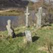
More than 120 site entries have been entered into the National Record of the Historic Environment, each record comprising a text description and a site-area polygon, often supplemented by photographs. The subject of each site entry varies from an individual structure, to a group of up to 45 shieling huts or a field system covering an area of 50 hectares. Some 290 ground photographs were added to the collection and the area was included in an HES aerial photographic sortie in August 2016. A handful of sites in the wider area were also recorded in order to provide comparanda.
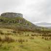
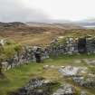
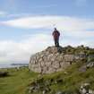
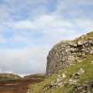
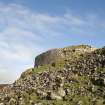
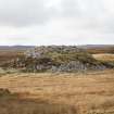
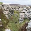
Much of the study area is now rough grazing extending up to 435m OD at An Cruchan, and recorded permanent settlement seems to have been concentrated on the coastline of the sea lochs to the north and south, and in particular at the NW of the study area between Kraiknish and Lon Luachrach. Prehistoric features are limited to the dun at Kraiknish (Canmore id: 11042) and two previously unrecorded hut circles near the Allt Sgeiteadh burn (e.g. 352756 ). The remaining features appear to date to the medieval and later periods, and include numerous groups of shieling huts which extend across extensive areas (e.g. 352737), and evidence different construction types suggesting lengthy use of the inland and upland areas for grazing. Settlements of this period are concentrated at Kraiknish where there is a sequence of township (352763) with a pre-Improvement tacksman’s house (352769), crofting township (352749) and farmstead (352751), while the township at Laimhrig na Moine is itself probably a product of clearance (330636). Expansion of the townships is represented by a small group of smallholdings at Lon Luachrach (e.g. 352758), as well as the establishment of a crofting township at Bualintur (119582). The remains of lazy bed cultivation and peat cutting cover extensive areas, the former being concentrated around the townships and smallholdings, the latter generally on the higher slopes nearby.
Information from HES Survey and Recording (GFG) 28 September 2017