551 359/6/1/496
Description Illustrations in 'Atlas to the Life of Thomas Telford, civil engineer', 1838
Date 1838
Collection General Collection
Catalogue Number 551 359/6/1/496
Category All Other
Permalink http://canmore.org.uk/collection/2843719
Collection Hierarchy - Batch Level
Collection Level (551 359) General Collection
> Group Level (551 359/6) SPECIAL COLLECTIONS
>> Sub-Group Level (RAB 359/6/1) ILLUSTRATIONS FROM PRINT ROOM BOOKS
>>> Batch Level (551 359/6/1/496) Illustrations in 'Atlas to the Life of Thomas Telford, civil engineer', 1838
| Preview | Category | Catalogue Number | Title | Date | Level |
|---|---|---|---|---|---|
 |
On-line Digital Images | SC 1021810 | Longitudinal section and plan of sea lock at Clachnaharry, Caledonian Canal. | c. 1838 | Item Level |
 |
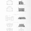
On-line Digital Images | DP 016489 | Engraving of elevation and plan inscr: ''Highland Churches and Manses.'' Includes plans, and elevations of church, one storey manse, and two storey manse. | c. 1838 | Item Level |
 |
On-line Digital Images | DP 018079 | Engraving of elevation and plan inscr: ''Timber Bridge over the River Spey at Laggan Kirk.'' Plan of the Roadway, Plan of the Framing and Plan of the Foundations. | 1838 | Item Level |
 |
On-line Digital Images | DP 018082 | Engraving of elevation and plan inscr: ''Elevation, Plan and Dimensions of Bridges in the Highlands of Scotland, made and constructed under the direction of The Commissioners for Highland Roads and Bridges 1803-1821.'' | 1838 | Item Level |
 |
On-line Digital Images | DP 018083 | Engraving of elevation and plan inscr: ''Plans and Dimensions of Harbours, Wharfs and Ferry-Piers made or improved under the direction of the Commissioner for Highland Roads and Bridges, 1806-1821.'' | 1838 | Item Level |
 |
On-line Digital Images | DP 018084 | Engraving of elevation and plan inscr: ''Glasgow and Carlisle Road. Fiddlers Burn Bridge, Bridge over the River Annan near Johnstone Mill in the County of Dumfries.'' | 1838 | Item Level |
 |
On-line Digital Images | DP 018085 | Engraving of elevation and plan inscr: ''Glasgow and Carlisle Road. Bridge over Birkwood Burn near Lismahagoh in the County of Lanark and Bridge over the River Aven near the Town of Hamilton in the County of Lanark.'' | 1838 | Item Level |
 |
On-line Digital Images | DP 017820 | Engraving of elevation and plan inscr: ''Birmingham and Liverpoool Junction Canal. Plan of a lock and longitudinal section''. | 1838 | Item Level |
 |
On-line Digital Images | DP 018799 | Engraving of elevation and plan inscr: ''Bridge over Mouse Water at Cartland Craigs, one of the Lanarkshire Road Bridges.'' | 1838 | Item Level |
 |
On-line Digital Images | DP 018800 | Engraving of elevation and plan inscr: ''Centering used in the construction of Cartland Craigs Bridge, 1821.'' | 1838 | Item Level |
 |
On-line Digital Images | DP 018801 | Engraving of elevation and plan inscr: ''Design for a Toll House at Cartland Craigs Bridge near Lanark.'' | 1838 | Item Level |
 |
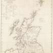
On-line Digital Images | DP 018803 | Engraving of map inscr: ''Map of Scotland shewing The Highland Roads and Bridges made, the Harbours improved and Churches built in the Highlands, also the Glasgow and Lanarkshire Roads, all according to the Plans of Thomas Telford. Shewing also the Old Military Roads still maintained in use.'' | c. 1838 | Item Level |
 |
On-line Digital Images | DP 018804 | Engraving of elevation and plan inscr: ''Glasgow Old Bridge shewing the addition to its width made with Cast Iron. '' | 1838 | Item Level |
 |
On-line Digital Images | DP 018805 | Engraving of elevation and plan inscr: ''Elevation of the Glasgow Bridge.'' Plan shewing the progressive stages of the work. Includes Longitudinal section, Elevation of Center Arch and Cross Section. | 1838 | Item Level |
 |
On-line Digital Images | DP 017821 | Engraving of elevation and plan inscr: ''Birmingham and Liverpoool Junction Canal. Aqueduct BRidge over the London and Chester Road near Nantwich. Elevatiom, Plans and Transverse Section.'' | 1838 | Item Level |
 |
On-line Digital Images | DP 017822 | Engraving of elevation and plan inscr: ''Map of the Great Fens: Especially of the North Level and of the New Line of Drainage from Clow's Crofts to the Nene Outfall.'' | 1838 | Item Level |
 |
On-line Digital Images | DP 017823 | Engraving of elevation and plan inscr: ''Plan of the Eau Brink Cut, and old Bed of the River Ouze.'' | 1838 | Item Level |
 |
On-line Digital Images | DP 017824 | Engraving of elevation and plan inscr: ''Map of the Nene Outfall, and part of the Drainage dependent on it. 1838'' | 1838 | Item Level |
 |
On-line Digital Images | DP 018806 | Engraving of elevation and plan inscr: ''Dean Bridge, Edinburgh.'' | 1838 | Item Level |
 |
On-line Digital Images | DP 018807 | Engraving of elevation and plan inscr: ''Gloucester Bridge. Elevation of the Centering.'' Also includes Elevation of the centers used in constructing the Dean Bridge, Edinburgh 1831. | 1838 | Item Level |
 |
On-line Digital Images | DP 018809 | Engraving of elevation and plan inscr: ''Bridge over the Tyne Water at Pathhead on the Edinburgh and Coldstream Road.'' Includes plan of foundations and plan of roadway. | 1838 | Item Level |
 |
On-line Digital Images | DP 018810 | Engraving of elevation and plan inscr: ''Bridge over the River Wansbeck at the Town of Morpeth in the County of Northumberland.'' Includes elevation, plan of roadway and foundations. | 1838 | Item Level |
 |
On-line Digital Images | DP 018812 | Engraving of elevation and plan inscr: ''Road Making.'' Includes cross sections of various types of road with foundations. | 1838 | Item Level |
 |
On-line Digital Images | DP 018813 | Engraving of elevation and plan inscr: ''Polish Road. Transverse section of the Road between the City of Warsaw and the Town of Brzesc in Lithuania.'' Includes a diagram showing Tools for making and repairing roads. | 1838 | Item Level |


