
South Ronaldsay, Mayfield


Enclosure (Period Unassigned)
Site Name South Ronaldsay, Mayfield
Classification Enclosure (Period Unassigned)
Canmore ID 9616
Site Number ND49SW 13
NGR ND 4307 9416
Datum OSGB36 - NGR
Permalink http://canmore.org.uk/site/9616


- Council Orkney Islands
- Parish South Ronaldsay
- Former Region Orkney Islands Area
- Former District Orkney
- Former County Orkney
ND49SW 13 4307 9416
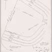
Situated at ND 4307 9416 in a non-defensive position is an enclosure comprised of two robbed semi-circular earth and stone ramparts with a medial ditch, enclosing on the landward side a roughly 'D' shaped flat and featureless area, about 45.0m in diameter.
The inner rampart has a maximum height of 1.3m and is 5.0m wide where it is best preserved in the N. The less well-defined outer rampart survives only in the NE and part of the SE quadrants where it averages 0.8m high and is up to 4.0m wide. The ditch averages 0.6m deep and 2.5m wide. An entrance through the inner rampart at its widest point (6.5m) in the E is suggested by two earthfast slabs 0.8m apart.
Surveyed at 1/2500.
Visited by OS (ISS) 26 April 1973
ND 430 941 Circular enclosure with external ditch, ?prehistoric.
Sponsors: Historic Scotland, Orkney Archaeological Trust
G Wilson and H Moore 1997.
Field Visit (August 1997)
A sub-circular enclosure, measuring 30m in diameter, occupies a small, low-lying promontory. It is defined by an earthen and stone bank with a ditch to the exterior. The bank stands up to 1.5m high and is 3m wide; it is best preserved to the N side. The ditch is now filled in but was probably originally up to 2m wide. A slight bank to the outer rim of the ditch may be upcast from ditch cutting. A 0.5m gap in the bank to the NE side and is flanked by two upright slabs and may be an entrance. The W side of the enclosure is much reduced and cannot be traced on the ground. It appears to extend beneath the foundations of a ruinous boat shed (see SR9). Here, exposed in the coastal section, a vertical sided cut, 2m in width is filled with rubble and peaty deposits.
Moore and Wilson, 1997
Coastal Zone Assessment Survey
Field Visit (30 April 2015)
ShoreUPDATE
As described, but the area described as the west side of the enclosure in the original survey (the south west side) has been altered by the demolition of the boat shed and the construction of a sea wall by the current owner which defends the garden and the house. The cut feature seen in the coastal section by the original surveyors is obscured by this sea wall.
On the north west side of the site the earthworks have been truncated by erosion, exposing a section through the bank and ditch. The ditch has been cut through the till and into the bedrock. A layer of grey sandy soil with charcoal flecks represents a buried soil which formed while the ditch was open.
Drystone structures have been built on top of this layer inside the ditch. These drystone walls form a stone lining on both sides of the ditch face. The wall on the inner face of the ditch runs along the line of the enclosure, and the wall facing the outer side of the ditch forms a corner, with one face running along the line of the enclosure and a return running perpendicular to this, along the coast edge.
The bank appears to have been formed of upcast material from the excavation of the ditch, and there are traces of stone facing on the inner side of the bank.
The uppermost fill of the ditch is a stoney rubble layer into which an orthostat has been set, and a modern wall has been constructed along the top parallel with the coast edge. The orthostat appears to be related to the construction of the modern wall rather than the enclosure.
Visited by Scotland's Coastal Heritage at Risk (SCHARP) 30 April 2015

