
Cockburn Law


Fort (Prehistoric)
Site Name Cockburn Law
Classification Fort (Prehistoric)
Canmore ID 58569
Site Number NT75NE 1
NGR NT 76576 59763
NGR Description Centre
Datum OSGB36 - NGR
Permalink http://canmore.org.uk/site/58569


- Council Scottish Borders, The
- Parish Duns
- Former Region Borders
- Former District Berwickshire
- Former County Berwickshire
NT75NE 1 76560 59760
(NT 7656 5976) Hill Fort (NR)
OS 6" map, (1957).
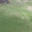
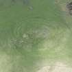
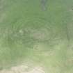
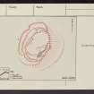
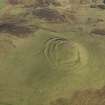
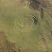
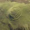
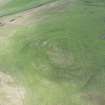
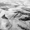
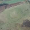
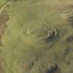
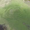
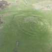
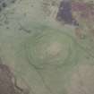
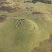
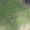
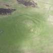
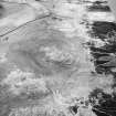
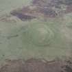
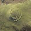
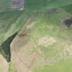
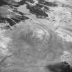
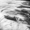
The fort on the summit of Cockburn Law is oval on plan, measuring 360ft by 280ft internally. It is defended on the E side by one rampart, on the S by two, and by three on the W and N, giving overall dimensions of 500ft by 380ft. There are three entrances, on the NW, W and S.
A row of large detached boulders runs along the base of the summit from the S entrance, returning at the N, to form an enclosure. There are obscure traces of structures within the fort (D Christison 1895).
RCAHMS 1915, visited 1908.
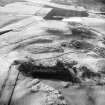
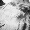
A fort, comprising earth and stone ramparts, generally as described. Within the interior, at the highest point, are the possible remains of a severely robbed cairn represented by a slight, turf-covered, stony bank 20.0m in diameter with a stony interior. Extending beyond this to the NE are bands of stone which possibly represent the footings of two circular huts and an enclosure.
Resurveyed at 1:2500.
Visited by OS (RD) 12 August 1970.
This complex fort is generally as described. The side of easiest approach is defended by three earth and stone ramparts (there is no evidence of ditches) with two staggered entrances. On the E side a single low rampart follows the top of steep natural hillslopes. A wide linear boulder spread which runs parallel to the foot of these slopes may be a further line of defence. A third entrance (on the S side of the fort) is approached by a terraced way. The 0.2m high stony banks which form the curvilinear internal detail at the summit cannot be readily interpreted; the two level circular areas may be the sites of huts, but the alleged cairn is not clearly identifiable. (See RCAHMS 1915 plan, fig.62).
Surveyed at 1:10,000.
Visited by OS (MJF) 4 July 1979.
Sherds of pottery from Cockburn Law Fort are in the National Museum of Antiquities of Scotland (NMAS) (Accession nos: HH 688 and HH 696). Also listed are a sling stone and another sherd of pottery 'from Cockburn Law' (Accession nos: HH 653 & HH 654).
NMAS Mss Catalogue undated.
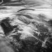
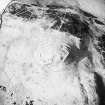
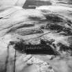
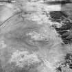
Photographed by CUCAP
CUCAP Air Photograph Catalogue.
Field Visit (8 August 1908)
116. Hill Fort, Cockburn Law.
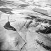
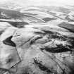
This fort (fig. 62) is situated around the summit of Cockburn Law, at an elevation of about 1066 feet above sea-level, its defensive lines enclosing the summit, which rises some40 feet above them. In general form the construction is oval, lying with its main axis nearly north and south, measuring some 500 feet by 380 feet over all, and some 360 feet by 280 feet in the interior. The east face at the edge of a steep natural scarp is defended by a single rampart, while at the south-west end the lines are doubled, and on the west and north-west, where access is by an easy gradient, they are trebled. They are stony mounds a few feet high and of moderate width. Towards the north the three lines cover a space of 125 feet in breadth, but as they sweep round the west flank they gradually converge, and at the south, after the cessation of the outer rampart, the two which remain are but 30 feet apart. The entrances are three, on the north-west, west, and south. That on the north-west passes obliquely through the outer and middle ramparts, and on either side of it the extremity of the middle rampart has been broken down, possibly for the site of a hut. The outer rampart is returned on either side at the opening so as to form a flanking defence. The entrance from the west occurs immediately beyond the termination of the outer rampart, and thence passes obliquely to an opening in the inner line. The south entrance is situated between the point of junction of the two inner mounds and the edge of the eastern slope. From below the south entrance and on the east side, a row of large detached boulders passes down the hill, and, returning at the north, forms an enclosure at the base of the summit.
See Antiquaries, xxix. p. 158 (plan and secs.); Christison, p. 294; Earthwork of England, pp. 194 and 203.
RCAHMS 1915, visited 8th August 1908.
OS Map: Ber., x. SW.
Note (29 January 2016 - 21 October 2016)
This fort occupies the summit of Cockburn Law and displays a complex configuration of defences that is unusual in any Scottish fort. Roughly oval on plan, it measures about 108m from NNE to SSW by 73m transversely (0.63ha) within its innermost rampart, which despite evidence of heavy robbing can be traced round the whole circuit, including the rocky escarpment that falls away sharply around the E flank. Elsewhere this inner line is supplemented by outer ramparts, comprising two on the S and three on the N and W, though whether as part of an unitary design or a cumulative scheme is unclear. Nevertheless, while the second rampart, embraces all the weaker flanks, returning and uniting with the inner on the W side of the entrance on the S, the third gives the impression that it was merely to elaborate the other two entrances on the N and W respectively; indeed, some of the aerial photographs appear to show the third rampart springing from the line of the innermost on the NNE. The pattern of the S entrance, however, is replicated at the WSW entrance, where the third rampart formerly returned and united with the second rampart on its N side; the gaps through the inner ramparts are also staggered here to create an oblique approach that exposes the visitors right side. This latter characteristic is emphasised still further at the entrance on the NNW, where the third rampart turns inwards to either side of the gap, leading the entrance way along the foot of the second rampart for a short distance before turning up the slope into the interior; unfortunately the terminals of the inner and second ramparts here are too robbed to reveal any other details. While these fortifications are entirely focussed on the summit area, a further line of enclosure, again very heavily robbed and reduced to little more than a band of stones and boulders, extends round the foot of the escarpment on the E, and is apparently broken by an entrance on the ESE; its purpose is unknown and there is no evidence that its interior communicated with that of the fort. The only features visible within the interior of the fort are the stony rim of what has probably been a large burial cairn [NT75NE 38] some 20m in diameter encircling the OS triangulation pillar, and several other stony rickles.
Information from An Atlas of Hillforts of Great Britain and Ireland – 21 October 2016. Atlas of Hillforts SC4051
Note (31 January 2020)
The location, classification and period of this site have been reviewed.
Sbc Note
Visibility: This is an upstanding earthwork or monument.
Information from Scottish Borders Council

