
Stonefieldhill


Settlement (Later Prehistoric)
Site Name Stonefieldhill
Classification Settlement (Later Prehistoric)
Alternative Name(s) Stonefield Hill
Canmore ID 53607
Site Number NT36SW 11
NGR NT 3044 6012
Datum OSGB36 - NGR
Permalink http://canmore.org.uk/site/53607


- Council Midlothian
- Parish Carrington
- Former Region Lothian
- Former District Midlothian
- Former County Midlothian
NT36SW 11 3044 6012.
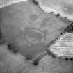
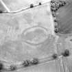
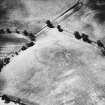
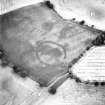
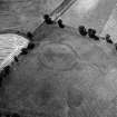
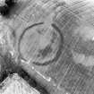
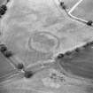
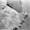
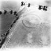
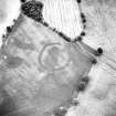
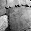
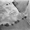
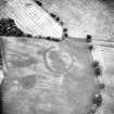
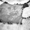
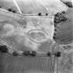
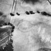
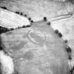
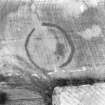
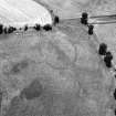
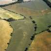
NT 3044 6012. Situated on a level platform below the crest of a slight rise in a cultivated field, the crop mark of an earthwork is visible on air photographs enclosing an area 86.0m E-W by 72.0m. Although nothing can be seen on the ground and no surface finds have been made, the farmer (G Brown, Stonefieldhill Farm) states that evidence of a circle can be seen when the field is newly sown and dry. A small oval mark within the interior may be the site of a hut suggesting that this was a possible homestead.
Site surveyed at 1:2500 from air photographs (RAF/F22/58/1263: 0003-4).
Visited by OS (RD) 1 March 1971
The ditches of this enclosure are about 6 m wide with expanded terminals at the opposed entrances on the W and E which are 12m wide. The site is reminiscent of a henge.
Univ Edinburgh Extra-mural Dept 1979
Excavation or the find of some artifact is required before the classification of this monument can be satisfactorily resolved.
H Welfare 1980
Scheduled as henge.
Information from Historic Scotland, scheduling document dated 13 November 1995.
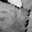
In 1976, aerial photographs (by John Dewar) of this enclosure revealed the presence of an internal rampart and cropmarks the following year indicated an area of scooping within the interior. These features suggest that the enclosure is probably a prehistoric settlement.
Information from RCAHMS (ARG) 10 October 1997.
The cropmark of this enclosure is visible on a vertical air photograph (OS 75/293/387-8, flown 1975).
Information from RCAHMS
Aerial Photographic Interpretation (25 June 1954)
Earthwork, Stonefield Hill (Carrington).
The ditch of a circular earthwork, about 300 ft. in diameter, on the flat top of a slight ridge a quarter of a mile SE of Stonefield HIll farm and at a height of 550 ft. OD. A crop-mark of lighter tone, which encloses the dark crop-mark of the ditch on the NE half of the work, suggests the presence of an external bank, and there are vague indications of two opposed entrances to the NW and SE arcs respectively. The foregoing structural features, the presence of the nearby stream, and the name Stonefield Hill, which, if it refers to this site, might conceivably be derived from the setting of standing stones which once stood in the central area, suggest the work may be a henge monument.
Information from RCAHMS (KAS) 25 June 1954
Aerial photographs: CPE/SCOT/UK 310, 5118-9
NT 305 601
Reference (1957)
This site is noted in the ‘List of monuments discovered during the survey of marginal land (1951-5)’ (RCAHMS 1957, xiv-xviii).
Information from RCAHMS (GFG), 24 October 2012.
Note (1988)
Stonefieldhill 1 NT 3044 6012 NT36SW 11
Cropmarks reveal an enclosure on the S side of a low ridge 400m SE of Stonefieldhill steading. Oval on plan, with wide entrances on the NW and SE, it measures 85m by 70m within a ditch which varies from 3m to 8m in breadth. Parchmarks on some of the available air photographs suggest the presence of an internal bank, and the identification of the enclosure as a Class II henge monument is unlikely.
RCAHMS 1988
(RCAHMS Survey of Marginal Lands; Welfare 1978, 6-7)
Aerial Photographic Transcription (14 March 2023)
An interpretative transcription, or mapping, of information on oblique aerial photographs was produced on 14 March 2023.

