
The Knock


Fort (Period Unassigned), Vitrified Stone (Period Unassigned)
Site Name The Knock
Classification Fort (Period Unassigned), Vitrified Stone (Period Unassigned)
Canmore ID 41289
Site Number NS26SW 2
NGR NS 2028 6286
Datum OSGB36 - NGR
Permalink http://canmore.org.uk/site/41289


- Council North Ayrshire
- Parish Largs
- Former Region Strathclyde
- Former District Cunninghame
- Former County Ayrshire
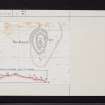
NS26SW 2 2028 6286.
(NS 2028 6286) Fort (NR)
OS 6" map (1963)
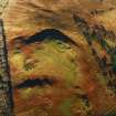
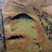
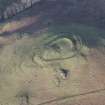
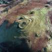
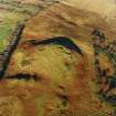
Fort: The summit of The Knock (712ft OD) is surrounded by a stony, turf-covered rampart, nowhere more than 3ft high, which encloses a sub-oval area about 165ft N-S by 95ft transversely. Enough vitrified material has come from the ruin to indicate that it had been a timber-laced wall (three pieces of vitrified stone were donated to the National Museum of Antiquities of Scotland (NMAS) by Childe - (Accession No: HH 479). On the flanks of the hill, from
6ft to 8ft below the crest of the rampart, a shallow, rock-cut ditch can be seen in the S, NW and N, bordered in places by a low rampart or upcast mound on the outer lip. The ditch fades to a terrace towards the W, and on the NE it has been destroyed by a modern access-road The original entrance may have been on the SE.
V G Childe and A Graham 1943; R W Feachem 1963
This fort is as described. The single rampart of earth and stone can be traced all round. Though Smith suggests that there were probably three ramparts, there is no suggestion of works other than those described.
Visited by OS (JLD) 21 September 1956
Previous field report confirmed. Some stone exposed on the outer face of the rampart at the S end of the fort may be vitrified.
Surveyed at 1.2500.
Visited by OS (WDJ) 28 October 1964
Vitrified sandstone was seen in mole upcasts all round the NW side; over 50 pieces were collected. A sherd of Early Iron Age pottery was also found. An approach road zig-zags up the N face of the hill towards the main fort entrance, 5ft wide, centrally placed in the N side, where the sharply inswinging end of the W rampart is covered by the squared end of the E rampart. A lower triangular terrace on the NW contained at least one hut. It may have been covered by a single palisade.
F Newall 1969
No change. Where the turf cover was broken, inspection showed no trace of vitrified material, although naturally decayed sandstone is evident. A single pebble-sized example of vitrifaction was found loose on the trackway below the W side rampart.
No trace of a hut platform or circle was found where indicated by Newall.
Visited by OS (JRL) 8 February 1983.
Field Visit (13 September 1942)
This site was included within the RCAHMS Emergency Survey (1942-3), an unpublished rescue project. Site descriptions, organised by county, vary from short notes to lengthy and full descriptions and are available to view online with contemporary sketches and photographs. The original typescripts, manuscripts, notebooks and photographs can also be consulted in the RCAHMS Search Room.
Information from RCAHMS (GFG) 10 December 2014.
Field Visit (31 May 1952)
This site was included within the RCAHMS Marginal Land Survey (1950-1962), an unpublished rescue project. Site descriptions, organised by county, are available to view online - see the searchable PDF in 'Digital Items'. These vary from short notes, to lengthy and full descriptions. Contemporary plane-table surveys and inked drawings, where available, can be viewed online in most cases - see 'Digital Images'. The original typecripts, notebooks and drawings can also be viewed in the RCAHMS search room.
Information from RCAHMS (GFG) 19 July 2013.
Note (31 July 2014 - 16 November 2016)
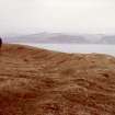
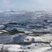
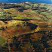
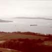
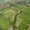
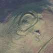
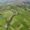
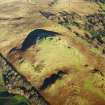
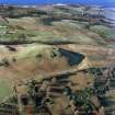
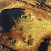
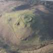
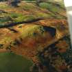
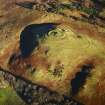
This small fort encloses the summit of The Knock, a steep-sided ridge between Brisbane Glen on the E and the sea on the W, with a panoramic view across the Clyde estuary. Oval on plan, it measures about 50m from N to S by 29m transversely (0.09ha) within a rampart which stands up to 0.9m high internally and on the N, NW and S falls away externally some 1.8m to 2.4m into a shallow rock-cut ditch, accompanied on the N by a low counterscarp bank; pieces of vitrified rock have been recovered from the rampart, though no trace of vitrifaction is currently visible. A triangular terrace outside the ditch on the S has also been taken into the circuit of the defences by the addition of a second ditch, though there is little trace of any accompanying rampart along the lip of the terrace. The entrance was probably on the SE, but has been destroyed by a later access track, which climbs the hill in a broad spiral. Apart from the OS triangulation pillar on the summit, the interior is featureless.
Information from An Atlas of Hillforts of Great Britain and Ireland – 16 November 2016. Atlas of Hillforts SC1286

