|
Photographs and Off-line Digital Images |
A 4269 CN |
Records of the Ordnance Survey, Southampton, Hampshire, England |
General view of The Knock vitrified fort. |
1983 |
Item Level |
|
|
Photographs and Off-line Digital Images |
A 4270 CN |
Records of the Ordnance Survey, Southampton, Hampshire, England |
View from fort |
1983 |
Item Level |
|
|
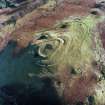
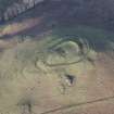
Photographs and Off-line Digital Images |
E 63314 CN |
RCAHMS Aerial Photography |
Oblique aerial view centred on the remains of the vitrified fort, taken from the SW. |
28/11/2005 |
Item Level |
|
|
Photographs and Off-line Digital Images |
E 63315 CN |
RCAHMS Aerial Photography |
Oblique aerial view centred on the remains of the vitrified fort, taken from the SSE. |
28/11/2005 |
Item Level |
|
|
Photographs and Off-line Digital Images |
E 63316 CN |
RCAHMS Aerial Photography |
Oblique aerial view centred on the remains of the vitrified fort, taken from the ESE. |
28/11/2005 |
Item Level |
|
|
Photographs and Off-line Digital Images |
E 63318 CN |
RCAHMS Aerial Photography |
Oblique aerial view centred on the remains of the vitrified fort, taken from the NW. |
28/11/2005 |
Item Level |
|
|
Photographs and Off-line Digital Images |
E 63319 CN |
RCAHMS Aerial Photography |
Oblique aerial view centred on the remains of the vitrified fort, taken from the WSW. |
28/11/2005 |
Item Level |
|
|
Photographs and Off-line Digital Images |
E 63320 CN |
RCAHMS Aerial Photography |
Oblique aerial view centred on the remains of the vitrified fort, taken from the W. |
28/11/2005 |
Item Level |
|
|
Photographs and Off-line Digital Images |
E 63321 CN |
RCAHMS Aerial Photography |
Oblique aerial view centred on the remains of the vitrified fort, taken from the WSW. |
28/11/2005 |
Item Level |
|
|
Photographs and Off-line Digital Images |
E 63322 CN |
RCAHMS Aerial Photography |
Oblique aerial view centred on the remains of the vitrified fort, taken from the SW. |
28/11/2005 |
Item Level |
|
|
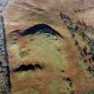
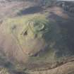
Photographs and Off-line Digital Images |
E 63317 CN |
RCAHMS Aerial Photography |
General oblique aerial view centred on the remains of the vitrified fort, taken from the ENE. |
28/11/2005 |
Item Level |
|
 |
On-line Digital Images |
SC 1015448 |
RCAHMS Aerial Photography |
Oblique aerial view centred on the remains of Knock vitrified fort, taken from the NW. |
28/11/2005 |
Item Level |
|
 |
On-line Digital Images |
SC 1015449 |
RCAHMS Aerial Photography |
Oblique aerial view centred on the remains of Knock vitrified fort, taken from the SW. |
28/11/2005 |
Item Level |
|
 |
On-line Digital Images |
SC 1015452 |
RCAHMS Aerial Photography |
General oblique aerial view centred on the remains of Knock vitrified fort, taken from the ENE. |
28/11/2005 |
Item Level |
|
 |
On-line Digital Images |
DP 062613 |
RCAHMS Aerial Photography Digital |
General oblique aerial view of the remains of the fort, taken from the W. |
6/2/2009 |
Item Level |
|
|
Manuscripts |
MS 36/24/8 |
Records of the Royal Commission on the Ancient and Historical Monuments of Scotland (RCAHMS), Edinbu |
The diary of Angus Graham, RCAHMS, Dec 1941 to Dec 1949. |
6/12/1941 |
Item Level |
|
|
Manuscripts |
MS 124/3 |
Records of the Royal Commission on the Ancient and Historical Monuments of Scotland (RCAHMS), Edinbu |
Field notebook No. 2, A Graham (RCAHMS). |
8/8/1942 |
Item Level |
|
 |
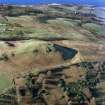
On-line Digital Images |
DP 104991 |
RCAHMS Aerial Photography Digital |
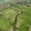
General oblique aerial view of Routenburn Golf Course and Knock Hill, taken from the SSW. |
25/7/2011 |
Item Level |
|
 |
On-line Digital Images |
DP 104992 |
RCAHMS Aerial Photography Digital |
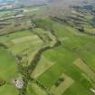
General oblique aerial view of Routenburn Golf Course and Knock Hill, taken from the S. |
25/7/2011 |
Item Level |
|
 |
Digital Files (Non-image) |
WP 000760 |
Records of the Royal Commission on the Ancient and Historical Monuments of Scotland (RCAHMS), Edinbu |
Scanned copy of RCAHMS Marginal Land Survey unpublished typescripts (Ayrshire), with index. |
1952 |
Item Level |
|
 |
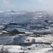
On-line Digital Images |
DP 175451 |
RCAHMS Aerial Photography Digital |
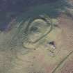
Oblique aerial view of The Knock fort, looking to the NNW. |
30/1/2014 |
Item Level |
|
 |
On-line Digital Images |
DP 175452 |
RCAHMS Aerial Photography Digital |
Oblique aerial view of The Knock fort, looking to the NW. |
30/1/2014 |
Item Level |
|
 |
On-line Digital Images |
DP 175453 |
RCAHMS Aerial Photography Digital |
Oblique aerial view of The Knock fort, looking to the SW. |
30/1/2014 |
Item Level |
|
 |
Digital Files (Non-image) |
WP 003404 |
Records of the Royal Commission on the Ancient and Historical Monuments of Scotland (RCAHMS), Edinbu |
RCAHMS Emergency Survey: Typescripts (Ayrshire). |
9/1942 |
Item Level |
|


