
Macharioch


Chambered Cairn (Neolithic)
Site Name Macharioch
Classification Chambered Cairn (Neolithic)
Alternative Name(s) Arg 34
Canmore ID 38693
Site Number NR70NW 5
NGR NR 7364 0927
Datum OSGB36 - NGR
Permalink http://canmore.org.uk/site/38693


- Council Argyll And Bute
- Parish Southend
- Former Region Strathclyde
- Former District Argyll And Bute
- Former County Argyll
NR70NW 5 7364 0927
(NR 7365 0927) Standing Stones (NR)
OS 6" map (1924)
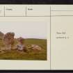
An isolated group of red sandstone conglomerate slabs comprising two massive orthostats with the others lying about their feet. It has been suggested that these may be the remains of a Clyde type chambered cairn (T G E Powell 1969) with the upright stones presumably belonging to a westward-facing facade, but this interpretation seems unlikely although it is difficult to offer an alternative (A S Henshall 1962).
The upright stones are contiguous, side by side, facing E-W and measuring 6ft 8ins and 4ft 3ins high and 9ft 4ins from end to end of the west faces, which are the flatter. To the east of these stones and lying almost at right angles to them, 4ft 9ins apart are two large prostrate slabs, the larger 4ft from the southern orthostat and the other 1ft from the northern. There are several other blocks of conglomerate among the small, probably field-gathered, stones heaped about the base of the four large stones.
RCAHMS 1971, visited 1962.
A setting of stones as interpreted by Henshall: they cannot be identified with certainty as the vestiges of a chambered cairn.
Surveyed at 1:2500.
Visited by OS (JB), 4 October 1977.
Field Visit (April 1962)
Chambered Cairn (probable), Macharioch (ARG 34).
In a level field 110m E. of Macharioch, and at a height of about 25 m O.D., there is an isolated group of stones (Fig. 18), all of red sandstone conglomerate, comprising two massive upright slabs and several recumbent slabs. In the absence of excavation the purpose of these stones is uncertain, but it is probable that they represent the remains of a chambered cairn. The two orthostats (numbers 1 and 2), which stand 2.0 m and 1.4 m in height respectively with their longer axes aligned N. and S., could be the portal stones of a burial-chamber or part of a facade, although their present position does not leave sufficient space for an entrance between them. Immediately to the E. of them the tops of four other stones (3-6) can be seen protruding above ground to a maximum height of 0.4 m; these appear to be side slabs of a chamber, measuring at least 2.4 m in length and 0·8 m in width internally, with its long axis running E. and W. A seventh stone (7), which is now lying with its N. edge leaning on stone 5, could be a dislodged cover-slab. Apart from a slight accumulation of small stones in the immediate vicinity, there is no trace of any cairn material.
RCAHMS 1971, visited April 1962
736092 cclxvi & cclxvii ("Standing Stones")
Excavation (September 2006)
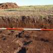
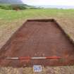
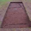
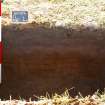
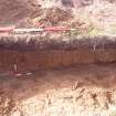
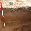
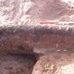
NR 73879 09413 A trench measuring 8 x 3m was excavated in September 2006 over a known lithic scatter. 500 flint pieces as well as a quartz assemblage was found. The remains of an ephemeral structure, which may once have held posts or a palisade, were found underneath the ploughsoil. No datable material was found in association with the structure. A series of test pits were also excavated at Macharioch and one contained part of a polished stone axe. Further fieldwalking and excavation is planned for 2007.
Archive: NMRS
Sponsors: University of Central Lancashire, Prehistoric Society, Cardiff University
Vicki Cummings and Gary Robinson - University of Central Lancashire / University of Wales, Bangor
Project (18 April 2009 - 2 May 2009)
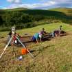
NR 173646 609268 An integrated programme of gradiometer, resistivity and magnetic susceptibility surveys, which aimed to identify the character of potential archaeology, was carried out around the upstanding stones of a possible chambered cairn from 18 April–2 May 2009. Two base lines were laid out using tapes. The first was aligned ENE and the second was orientated at 90° to the first. The NE origin peg for both base lines was at NR173610 609275. The surveys, which did not incorporate the scheduled area, detected a series of anomalies.
The gradiometer survey was carried out over four 30m grids, using a Bartington Grad601 dual sensor vertical
component fluxgate gradiometer, and a sampling interval of 0.25m on a 1m traverse. Even without processing it is clear that the chambered cairn has not been removed by ploughing and extends well beyond the scheduled area (see plot). The extreme values from the stones suggest that igneous rock may have been used in its construction.
The resistivity survey was carried out over four 20m grids, using a Geoscan RM15 twin probe with 0.5 spacing, and a sampling interval of 0.5m on a 1m traverse. Once again the tomb is apparent but the contrast between positive and negative readings is not particularly pronounced. This could be because the ploughsoil covering the monument is too deep, with the archaeology below 0.5m, or simply bland results due to the saturated state of the ground (heavy rain occurred before and during the survey).
Previous fieldwork had identified lithic scatters on the N side of this field (DES 2006), and an attempt was made to determine whether an increased level of activity could be detected in relation to these scatters. Four 100m grids were sampled at 10m intervals with a Bartington MS2 magnetic susceptibility meter with a MS2D field survey 185mm loop sensor. A fifth grid was limited to 80m by the field boundary.
The results show a large anomaly running N–S within the E side of the survey area. Test pitting carried out in the next field (DES 2006) had demonstrated the presence of ancient dune systems below thin topsoil. This dune system probably continues into our survey area and would explain these results. A second trend in the data seems to be higher readings as the field slopes to the S. This may indicate increased human settlement activity closer to Macharioch Bay. Further data processing from all surveys is required.
Archive: RCAHMS (intended)
Funder: University of Central Lancashire
Vicki Cummings and Gary Robinson – University of Central Lancashire/Bangor University
Magnetometry (18 April 2009 - 2 May 2009)
NR 173646 609268 Magnetometry survey.
Archive: RCAHMS (intended)
Funder: University of Central Lancashire
Vicki Cummings and Gary Robinson – University of Central Lancashire/Bangor University
Magnetic Susceptibility (18 April 2009 - 2 May 2009)
NR 173646 609268 Magnetic susceptibility survey.
Archive: RCAHMS (intended)
Funder: University of Central Lancashire
Vicki Cummings and Gary Robinson – University of Central Lancashire/Bangor University
Earth Resistance Survey (18 April 2009 - 2 May 2009)
NR 173646 609268 Resistivity survey.
Archive: RCAHMS (intended)
Funder: University of Central Lancashire
Vicki Cummings and Gary Robinson – University of Central Lancashire/Bangor University
Magnetometry (18 April 2009 - 2 May 2009)
NR 173646 609268 Magnetometry survey.
Archive: RCAHMS (intended)
Funder: University of Central Lancashire
Vicki Cummings and Gary Robinson – University of Central Lancashire/Bangor University

