
Following the launch of trove.scot in February 2025 we are now planning the retiral of some of our webservices. Canmore will be switched off on 24th June 2025. Information about the closure can be found on the HES website: Retiral of HES web services | Historic Environment Scotland
Dalvorar


Corn Drying Kiln(S) (Post Medieval), Encampment (17th Century), Hunting Lodge (19th Century)(Possible), Township (Post Medieval)
Site Name Dalvorar
Classification Corn Drying Kiln(S) (Post Medieval), Encampment (17th Century), Hunting Lodge (19th Century)(Possible), Township (Post Medieval)
Alternative Name(s) Mar Lodge Estate; Glen Dee; Dail A' Mhoiraire Mhor; Dail A' Mhoraire Bheag; Mar; Dubrach To East Dalvorar
Canmore ID 27747
Site Number NO08NW 1
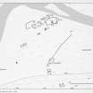
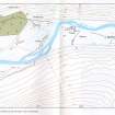
NGR NO 040 893
NGR Description Centred NO 040 893
Datum OSGB36 - NGR
Permalink http://canmore.org.uk/site/27747


- Council Aberdeenshire
- Parish Crathie And Braemar
- Former Region Grampian
- Former District Kincardine And Deeside
- Former County Aberdeenshire
Field Visit (18 October 1967)
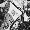
NO08NW 1 centred 040 893
See also NO08NW 3, 4, 7 and 9.
(Area centred: NO 040 893) Viscount Dundee and his army encamped on his way to the Battle of Killiecrankie (27th July 1689) at two adjoining 'larachs', Dail a Mhoraire Mhor and Dail a Mhoraire Bheag. (now named Dalvorar)
(A I McConnochie 1898)
'Dalvorar,' minor depopulation. No trace of army encampment.
Visited by OS (R L) 18 October 1967
Observation (1987)
Smith notes Dalvorar under two site-numbers; the E end of the township (NO 047 892) is his site 12, and the W end of the township (NO 039 894) is his site 13.
Site 12:
Longhouse with rounded corners, 12m by 6m, on the hill slope above Dee floodplain beyond head-dyke. Longhouse, 7m by 5m, with possible collapsed kiln at west end, set into slope. Also on hillside, a 12m by 5m longhouse with rounded corners. At the back of heather-dominated terrace, a longhouse 12m by 5m and another 7m by 4m, with enclosure 22m by 8m with single entrance and stone clearance heaps. A longhouse, 20m by 6m, partitioned into three is tacked on to the enclosure wall. A longhouse, 12m by 5m, is associated with a curvilinear plot and stone clearance heaps. A longhouse, 12m by 5m, with stone platform and stone cell at end, also tacked on to enclosure. Another longhouse, 12m by 5m. Formerly cultivated 'greens' with stone clearance heaps.
Site 13:
Stone-walled enclosure to south tacked on to longhouse, 8m by 5m, with associated foundations 4m by 2m. Longhouse, 16m by 5m, to east with two entrances directly opposite each other. There are clear signs of stone clearance activity within the enclosure, together with a stone cairn some 6m in diameter with slight collapse in centre, possibly a kiln. On the nearby terrace bluff, a kiln 2m in diameter inset and a longhouse 10m by 5m. Longhouse, 12m by 7m, with possible curved wall foundation underlying it at east end. The main building stands to seven courses at the western end.
A longhouse, 8m by 4m, underlying mortar-built or strengthened building, 18m by 7m. Near the floodplain margin, a stone enclosure 22m by 12m, with an indeterminate rectangular foundation outside. On the hillside above, set normal to the slope, two longhouses, 12m by 5m, both beyond the head-dyke which runs along the inner edge of the floodplain.
J S Smith 1987
Field Visit (21 July 1993)
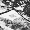
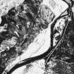
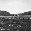
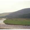
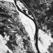
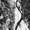
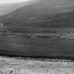
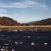
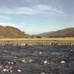
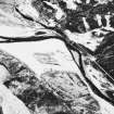
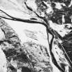
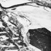
There are two clusters of buildings, characterised by faced-rubble footings up to 0.9m in thickness, at the E and W ends of haughland on the S side of the River Dee, some of which are depicted on the current edition of the OS 1:10,000 map under the name of Dalvorar. The 1st edition of the OS 6-inch map (Aberdeenshire 1869, sheet xcvii) also depicts some unroofed buildings - the W group (centred on NO 0390 8934) under the name of Dail a'Mhoraire Mhor (three buildings and three enclosures) and the E cluster (centred on NO 0435 8925) as Dail a'Mhoraire Bheag (five buildings). Parts of the haughland have been cleared of stone and may have been cultivated, although no rig is visible.
The W settlement (Dail a'Mhoraire Mhor) is largely situated at the N edge of the haughland, along the S side of the Dee, although there are two parallel buildings (MAR93 471-472) levelled into the heather-covered valley-side to the S.
Thirteen buildings (MAR93 392-394, 397, 399-400, 469, 471-475) measure between 5.8m by 3.6m and 13.8m by 3m internally, while two larger buildings measure 15m by 4.4m internally (MAR93 396) and 19.3m by 4m internally (MAR93 469). Two of the buildings (MAR 399, 400) are constructed with square angles and lie parallel to each other, perhaps forming a relatively late element in the settlement. The N side of one building (MAR93 400) still stands up to 2.5m in height and has been mortared. It is wider than most other township buildings, at 4.5m, and has a window and joist-sockets in the N wall, and may have been the centre of a post-clearance sheep farm (Watson and Allan 1990), with which the drystone field banks enclosing the haughland to the E, N and W may be related (see also NO08NW 2-5, 8, 9).
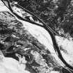
The two parallel buildings which have been suggested as a post-clearance sheep-farm, have characteristics which match those of the buildings at the shooting-lodges of Bynack and Geldie. The mortar-walled building (MAR93 400) is similar to the lodge-houses at Bynack and Geldie (N0 08NW 17 and NN 98NE 1), whilst the other building (MAR93 399), which has three entrances on one side and what may be drains running across it, may have been a stables. In addition, following the abandonment of the sheep-farm in about 1832, Dalvorar was let to James Duff esq., a relation of the Earl of Fife, who may have used it as a shooting-lodge (Aberdeen University Library MS 3175).
There are two stone-walled enclosures, both depicted as hedged on the 1st edition of the OS map (ibid) attached to two of the buildings (MAR93 395, 400). A rectangular stony platform (MAR93 468), which may have been a stack-stand, is also situated within the scatter of buildings (NO 0388 8930).
There are two kilns amongst the buildings of the W settlement. The better-preserved kiln (MAR93 398) has a bowl measuring 2.1m by 1.9m across and 0.8m deep, and while what may be a ruinous kiln, set within a mound measuring 5.5m in diameter (MAR93 395), lies in one of the enclosures.
A hut (MAR93 470), measuring 6.1m by 2m within faced-rubble walls 1m in thickness and 0.3m in height, is situated above the steep slopes forming the S bank of the Dee and lies to the SW of the buildings, immediately to the W of an unnamed burn.
The E settlement consists of seven buildings (MAR93 383, 385-8, 390-1), two huts (MAR93 384, 389) and a kiln (MAR93 382). The buildings are aligned from E to W and generally measure between 11.3m by 4.1m and 6.2m by 3.2m internally with one larger building (MAR93 388) measuring 17.8m by 3.3m internally. The huts measure between 5.4m by 2.5m and 2.4m and 1.8m internally, and the bowl of the kiln measures 1.9m across. A ruinous drystone wall cuts across the angle of the Dee to the SE and NW of the buildings.
Dalvorar is depicted on Farquharson's map of the Forrest of Mar (1703) (National Library of Scotland) and is also shown on Roy's map (Roy 1747-55), although under the name of Dubrach, presumably transposed from the settlement to the W. Robertson's map of 1822 (Robertson 1822) also shows the site, in a location which would correspond to the mortared, two-storey building (NO 0386 8933, MAR93 400) which may have been the focus for a post-clearance sheep farm.
(MAR93 382-400, 468-475)
Visited by RCAHMS (DCC) 21 July 1993
Note (22 March 1999)
Further examination of the 1st edition of the OS 6-inch map (Aberdeenshire 1869, sheet xcvii) shows three unroofed buildings and three enclosures in the township group to the W and four unroofed buildings in the group to the E. Ten unroofed buildings, four enclosures and a length of wall are depicted on the current edition of the OS 1:10000 map (1971).
Information from RCAHMS (SAH) 22 March 1999
Archaeological Evaluation (2003)
NO 040 893 An analytical survey and limited archaeological evaluation were undertaken in December 2002 at the ruins of the mortared masonry structure within the Dail a' Mhorair Mhor group of structures within the wider Dalvorar township.
While the elongated rectangular plan form and variations in masonry fabric suggested the possibility of pre-19th-century origins, the detailed survey and evaluation demonstrated this not to have been the case. The structure appears to overlie the remains of an earlier building platform, the remains of which extend out to the N.
The structure had been gabled to the E and W, with parts of a substantial fireplace surviving to the W; a central entrance to the S and a central window to the N remain. Single windows probably existed on either side of the entrance. Traces of wallplaster survive on the interior face of the N wall, revealing the former presence of a N-S framed partition to the E of the central window. Common joist sockets survive within the N wall for a loft floor structure.
A 1m wide evaluation trench was located at either side of the central part of the rear N wall of the structure. Internally, destruction deposits were found to overlie the remains of a flagstone floor. Finds recovered include 19th-century white wares, bottle glass, and fragments of fine wine glasses, consistent with documentary sources that the structure had functioned as a gamekeeper's house and shooting lodge. The building appears to have been abandoned by the 1860s.
Sponsor: NTS.
T Addyman 2003.
Management (2009)
Scheduled with NO08NW 3, 4, 7 and 9 as 'Mar, townships, field systems, stills and kilns, Dubrach to E[ast] Dalvorar'.
Information from Historic Scotland, scheduling document dated 30 March 2009.

