
Ettleton Sike


Building (Post Medieval), Field System (Medieval) - (Post Medieval), Rig And Furrow (Medieval) - (Post Medieval), Sheepfold (Period Unknown)
Site Name Ettleton Sike
Classification Building (Post Medieval), Field System (Medieval) - (Post Medieval), Rig And Furrow (Medieval) - (Post Medieval), Sheepfold (Period Unknown)
Canmore ID 162993
Site Number NY48NE 169
NGR NY 4702 8640
Datum OSGB36 - NGR
Permalink http://canmore.org.uk/site/162993


- Council Scottish Borders, The
- Parish Castleton
- Former Region Borders
- Former District Roxburgh
- Former County Roxburghshire
Field Visit (17 April 1996)
NY48NE 169 4702 8640
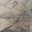
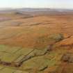
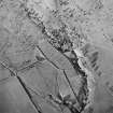
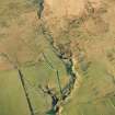
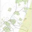
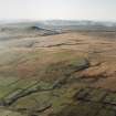
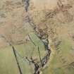
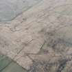
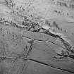
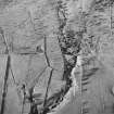
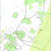
The turf footings of this rectangular building lie on a small terrace to the S of the Ettleton Sike. The building measures 7.5m from N to S by 2.6m internally and has a byre drain in the S half of the interior. A trackway cutting across the centre of the building has obscured the entrance which may have been in the E side. The building overlies a field-bank that extends from the Ettleton Sike and fades away in increasingly boggy ground to the S (NY 4703 8631). Rig, most clearly visible on vertica aerial photographs (543/RAF/1507 F22: frame no.0204, 2 November 1961) and measuring about 5m between furrows, lies to the NW of the bank. The ground to the E of the bank bears very faint traces of rig, smoothed by recent ploughing. Further banks in this area define three fields to the S of the sike and probably overlie the rig; probably post-dating the bank overlain by the building also. A fragmentary length of bank in the field to the SE of Ettleton Cemetery (from NY 4727 8627 to 4733 8622) may be part of the same system which predates the laying out of the Newcastleton crofts. A turf bank butted against the N side of this field-bank defines a narrow corridor which may have been a sheepfold (NY 4732 8622).
(LID96 38)
Visited by RCAHMS (DCC) 17 April 1996

