
North Uist, Buaile Caragarry, Dun Caragarry


Dun (Prehistoric), Hut (Post Medieval)
Site Name North Uist, Buaile Caragarry, Dun Caragarry
Classification Dun (Prehistoric), Hut (Post Medieval)
Canmore ID 10429
Site Number NF96SW 6
NGR NF 9221 6407
Datum OSGB36 - NGR
Permalink http://canmore.org.uk/site/10429


- Council Western Isles
- Parish North Uist
- Former Region Western Isles Islands Area
- Former District Western Isles
- Former County Inverness-shire
NF96SW 6 9220 6402.
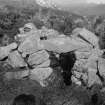
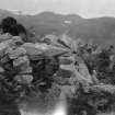
(Area NF 925 640) Dun Caragarry, situated at a considerable elevation halfway up the shoulder of South Lee, occupying a narrow ridge of great natural strength. The entrance appears to have been towards the E, although no remains of the doorway could be verified. Double walls are traceable here and at the S, and have been combined with natural features to form an enclosure c.35 x 48ft at the centre of which is an almost perfect domed cell, formed by a wall 2-3ft thick, mainly circular, interior c.6 1/2 x 5ft, with the doorway on the W. The slope of a massive boulder, forming part of the defence system on the W, produces a cave-like recess which has been enclosed by low walls to form an oblong chamber 10 x 6ft. Within was found a layer of undisturbed kitchen-midden remains. Potsherds, bone, shells, ashes, etc. were also found in the exterior wall on the S of the fort. Outside its E end is a shelter, perhaps a guard-chamber, and to the SE, 20-30 yards down the slope, is a probable cattle-pen.
North Uist 1911; RCAHMS 1928.
NF 9220 6402. Dun Caragarry is as described above.
Visited by OS (R D) 11 June 1965.
Field Visit (3 August 1915)
Dun Caragarry, Bualie Caragarry, Loch Eport.
Overlooking the mouth of Loch Eport,some 400 yards north-west of the ruined shielings known as Buaile Caragarry, at an elevation of about 300 feet above sea-level, on the rocky south-eastern slope of South Lee, is the defensive site, Dun Caragarry, occupying the summit of a detached, narrow ridge running down the hill towards the east-south-east, which is only reached after a stiff climb. The northern flank is protected by a gully bordered with precipitous rocks, and the other side is almost inaccessible owing to the steepness of the slope, which is broken up by outcrops of rock. The western and higher end is defended by a huge block of rock over 12 feet in height, which has fallen from the cliff above, and access to the dun has been obtained along the sloping ridge at the eastern end. Short sections of drystone building fill up the gaps between the rocks on the flanks, and on either side of the boulder at the western extremity, and there have probably been double walls at the eastern end. Most of the building has collapsed, but on the northern side a portion remains in position for 13 feet in length, and 6 feet in height at the centre. The area enclosed is of small extent, measuring some 40 feet in length, and 35 feet in breadth. N ear the centre of the fort is a beehive cell of drystone building wanting only the roofing slabs. It is an irregular oval, measuring internally some 7 feet in length and 4 feet in breadth, and showing a height of 4 feet 6 inches above the fallen stones on the floor. The wall is from 2 to 3 feet thick, and the entrance on the west, which still shows the lintel in position, is 4 feet 2 inches high and 1 foot 3 inches wide at the narrowest part. There are several rock shelters without the dun, the most prominent being near the eastern end of the northern flank. This cavity under a huge slab of rock measures 11 feet long, 5 feet 9 inches broad, and 2 feet 4 inches high, and the western end of the opening is filled in with rough building. A quantity of limpet and whelk shells, and a few bones, are seen under the shelving eastern side of the large rock at the western end of the dun.
Some 20 to 30 yards down the steep southern slope of the ridge below the dun there have been some stone walled enclosures, possibly for stock; but these are in a very dilapidated condition.
RCAHMS 1928, visited 3 August 1915.
OS map: North Uist xl (unnoted).

