
Pricing Change
New pricing for orders of material from this site will come into place shortly. Charges for supply of digital images, digitisation on demand, prints and licensing will be altered.
Upcoming Maintenance
Please be advised that this website will undergo scheduled maintenance on the following dates:
Thursday, 30 January: 11:00 AM - 3:00 PM
During these times, some functionality such as image purchasing may be temporarily unavailable. We apologise for any inconvenience this may cause.
Tinnis Hill


Cairn (Prehistoric), Plantation Bank(S) (Post Medieval)(Possible)
Site Name Tinnis Hill
Classification Cairn (Prehistoric), Plantation Bank(S) (Post Medieval)(Possible)
Canmore ID 67879
Site Number NY48NW 1
NGR NY 4309 8545
Datum OSGB36 - NGR
Permalink http://canmore.org.uk/site/67879


- Council Scottish Borders, The
- Parish Castleton
- Former Region Borders
- Former District Roxburgh
- Former County Roxburghshire
NY48NW 1 4308 8545.
(NY 4308 8545) Cairn (NR)
OS 6" map (1957)
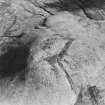
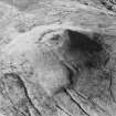
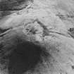
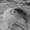
The ruins of a cairn occupy the summit of Tinnis Hill (1326 ft OD); all that remains is a low spread mound of small boulders measuring about 30 ft by 35 ft, on top of which a modern cairn has been built.
At a low level, the summit-knoll is encircled by a narrow terrace, faced with drystone masonry and carrying a slight turf bank. This is probably only a plantation bank, while a second enclosure immediately surrounding the cairn may have been intended to isolate the ruins within the planted area.
RCAHMS 1956, visited 1949
The 0.3m high cairn has been so spread that it is now indistinguishable from the low enclosing bank which measures approximately 18.0m by 17.0m. An Ordnance Survey triangulation pillar stands on the E side of the cairn and a crude stone shelter has replaced the modern cairn. The footings of a sub-oval stony bank, 60.0m by 50.0m, survive just below the summit area. Its origin and purpose are not clear and whether it is a plantation bank is a matter of conjecture.
Surveyed at 1:10,000.
Visited by OS (MJF) 31 July 1979.
The remains of a round cairn are situated on the summit of Tinnis Hill. It measures 19.5m in diameter but has been heavily robbed and is now no more than 0.6m high. An OS triangulation station on the NE edge of the cairn is enclosed by a low drystone wall.
The cairn has probably been robbed to provide stone for the now-ruinous wall that encloses the top of the hill.
Visited by RCAHMS (ARW, SPH), 27 April 1993.
Field Visit (11 May 1949)
Cairn and Enclosures, Tinnis Hill (NY 430 854)
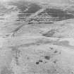
Tinnis Hill is a steep-sided cone of fairly regular profile, which rises on the S., W., and N. from a broad ridge of boggy moorland lying some 300 ft. below its summit (1326 ft. O.D.), and on the E. from the deep valley of the Tinnis Burn. It commands a wide view over Cumberland to the Lake District mountains, the Solway, Dumfriesshire, and Liddesdale. The summit is flattish; but from about the centre of the flattened area there rises a rocky boss or knoll, and on this are to be seen a cairn together with a smaller and a larger enclosure.
The cairn has been completely ruined, all that now remains being a low, spread mound of small boulders measuring about 30 ft. by 25 ft. On top of this there has been built a modern surveyor's cairn or landmark. Immediately surrounding the cairn is a small sub-rectangular enclosure, now represented by a grass-covered foundation-mound of small boulders up to 6 ft. thick over all. Its sides are slightly convex and its angles slightly rounded, and it may well be of later date than the cairn - which is not placed at its centre - as its E. side seems to impinge on the edge of the spread. It has no entrance, and it measures 57 ft. by 44 ft. overall. A somewhat similar enclosure has been noted at the cairn on Windburgh Hill (No. 291). At a lower level the summit-knoll is encircled by a narrow terrace, faced with drystone masonry and carrying a slight turf bank on its lip for most of its length. This outer enclosure seems too slight to have been defensive, and, unsuitable as such a hilltop is for the planting of trees, it is probably no more than a plantation bank. In that case, the inner one might likewise have been intended to isolate the ruins of the cairn within the planted area.
RCAHMS 1956, visited 11 May 1949
OS Map: N xl ("Cairn" in ordinary type).
Field Visit (26 February 1996)
This heavily robbed cairn is generally as previously described, measuring 18.8m in diameter and 0.5m in height. A rough stone shelter has been built against the OS triangulation pillar, which stands on the NE edge of the cairn, and in the centre of the cairn there is a hollow surrounded by upcast stone.
Around the base of the knoll that crowns the summit of the hill there is a drystone wall, 0.7m high and 1.4m thick, reduced in places to a stony bank, which encloses an oval area measuring 60m by 53m. This may be a plantation bank, although no evidence of any stumps or tree throws was noticed within the enclosed area.
(LID96 151-2)
Visited by RCAHMS (SDB) 26 February 1996
Sbc Note
Visibility: This is an upstanding earthwork or monument.
Information from Scottish Borders Council

