
Raeburnfoot


Fort Annexe (Roman), Roman Fort (Roman)
Site Name Raeburnfoot
Classification Fort Annexe (Roman), Roman Fort (Roman)
Canmore ID 67274
Site Number NY29NE 5
NGR NY 2510 9908
Datum OSGB36 - NGR
Permalink http://canmore.org.uk/site/67274


- Council Dumfries And Galloway
- Parish Eskdalemuir
- Former Region Dumfries And Galloway
- Former District Annandale And Eskdale
- Former County Dumfries-shire
NY29NE 5 2510 9908.
(NY 2510 9908) ROMAN FORT (R)
OS 6" map (1965).
For (Netherby-Bentpath) Roman road up the Esk valley, see NY39SW 25 and related references.
The two Roman forts at Raeburnfoot, one inside the other, were first discovered in 1810, when their dimensions were as shown in the NSA (1845). They were subsequently much reduced by ploughing.
Excavations were carried out before 1897, 1946 and 1959. The larger fort measured internally c. 530' N-S by 360', and was defended by a clay rampart 18'-19' wide and a single ditch 18' wide. Only two entrances were discovered, in the N and S sides. No remains of buildings were identified, and the fact that the rampart was of clay suggests it may never have been permanently occupied (A S Robertson 1959). I A Richmond gave information to the OS (1953) that he thought it may have been a large fort for 500 cavalry.
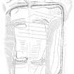
The 1959 excavations showed that the inner fort or large fortlet was Antonine and measured c. 210' by 240' internally. It was defended by a turf rampart c. 20' wide, and by 2 ditches, each less than 10' wide. There were gates in the N and S sides, and inside were discovered the sleeper trenches of what appeared to be barrack blocks, each c. 48' x 24'. Finds included 2nd. c pottery, amphorae, glass ornaments etc.
J Barbour 1898; J K St Joseph 1947; RCAHMS 1920, visited 1912
As described and planned. Revised at 25".
Visited by OS (WDJ) 27 August 1962 and (IA) 12 October 1973
No change to previous field report.
Visited by OS (MJF) 1 September 1978
Field Visit (August 1980)
Raeburnfoot NY 251 990 NY29NE 5
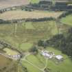
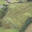
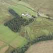
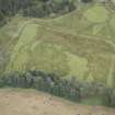
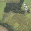
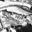
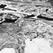
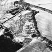
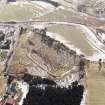
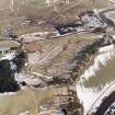
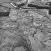
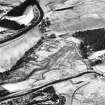
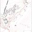
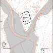
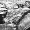
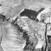
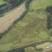
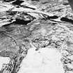
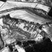
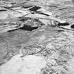
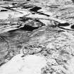
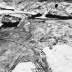
Situated on the level summit of a low hillock overlooking the confluence of the River White Esk and the Rae Burn, some 90m SW of Raeburnfoot farmhouse, there are the well-preserved remains of a small Roman fort. Measuring about 73m by 64m internally, it was defended by a turf rampart (up to 8.2m thick and 1m high) and two ditches; there are two entrances, directly opposed, on the NNW and SSE respectively. The fort lies within a roughly rectangular enclosure - presumably an annexe - measuring 165m by at least 110m within a single ditch and rampart; the defences of both fort and annexe have been truncated on the W by the erosion of the steep scarp above the River White Esk. Excavation in 1959-60 revealed that the interior of the fort contained a number of timber buildings and cobbled streets, but the plan, as far as it could be seen, was not that of a standard fort. There was apparently only one occupation, in the Antonine period. The finds from this and earlier excavations are in Dumfries Museum (DUMFM 1934/68, 1963/10).
RCAHMS 1980, visited August 1980
(RCAHMS 1920, pp. 68-70, No. 172; Robertson 1961; 1964, 198)
Publication Account (1986)
This small fort stands on a plateau just above the confluence of the River Esk and Rae Bum at Eskdalemuir, close to the point where the Roman road to Newstead can be assumed to have crossed the Esk and its flood plain. Raeburnfoot was probably a roadside station characteristic of Antonine organisation, and provided quarters for patrols, signallers or convoy guards. Excavation confIrmed that the fort was of the early Antonine period, but the evidence indicated only a single and brief phase of occupation.
The fort is unusual in having an outer parallel enclosure, and in having no man-made defences on the steeply scarped western edge. It was once believed that this outer circuit was the original work and that its western defences had been lost to river erosion. However, this natural scarp remains probably much as it was in Roman times, and the two enclosures appear to have been contemporary, the outer one, which yielded no evidence of buildings, possibly having been an annexe.
The site was chosen primarily to suit the inner enclosure. It has a rampart and twin ditches (except on the west), and the interior, which covers an area of about 0.6 ha, contained at least nine wooden buildings, mostly identifIable as barrack blocks. Two of the central group may have had a different, possibly administrative purpose, hence the classifIcation as a small fort rather than a large fortleti a fortlet is usually made up exclusively of barrack accommodation.
Information from ‘Exploring Scotland’s Heritage: Dumfries and Galloway’, (1986).
Measured Survey (5 October 1992 - 9 October 1992)
RCAHMS surveyed the Roman fort at Raeburnfoot between 5-9 October 1992 with plane-table and self-reducing alidade at a scale of 1:500. The plan was redrawn in ink and published at a scale of 1:1000 (RCAHMS 1997, Fig. 178).
Note (1997)
NY 2510 9908 NY29NE 5
Listed as fort.
RCAHMS 1997.

