
Rae Burn


Ring Enclosure(S) (Post Medieval)
Site Name Rae Burn
Classification Ring Enclosure(S) (Post Medieval)
Alternative Name(s) Raeburnfoot; Moodlaw Burn
Canmore ID 67237
Site Number NY29NE 16
NGR NY 2548 9974
Datum OSGB36 - NGR
Permalink http://canmore.org.uk/site/67237


- Council Dumfries And Galloway
- Parish Eskdalemuir
- Former Region Dumfries And Galloway
- Former District Annandale And Eskdale
- Former County Dumfries-shire
NY29NE 16 254 997.
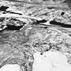
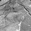
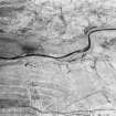
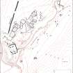
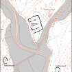
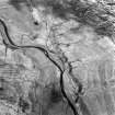
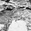
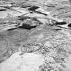
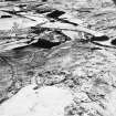
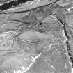
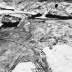
Along either side of the valleys of the Rae Burn and Moodlaw Burn are several groups of circular and oval turf-banked enclosures. Their situations are varied, including areas of marsh, sloping ground and the flood plain, with one built within the Roman fort NY29NE 17. They range in size from 5.0m to 8.0m in diameter overall with banks measuring up to 3.0m wide and 0.5m high; in some cases the interior is raised above the level of the surrounding ground. Not one has an entrance. Some of these enclosures occur with field banks of similar construction.
Although many of these have been considered as hut circles, the lack of entrances, the smallness of the interior, the unsuitable locations and the turf bank construction make this unlikely.
The precise period of construction is uncertain, but some of them are certainly associated with turf field banks and the probability is that they were used as stock pens in the early modern period. They are referred to locally as 'sod dykes' and one informant confirms that they were used as sheep pens.
Visited by OS (WDJ) 21 August 1962 and (IA) 9 October 1973.
RCAHMS 1920.
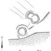
Measured Survey (5 June 1992)
RCAHMS surveyed the ring-enclosures at Rae Burn on 5 June 1992 with plane-table and self-reducing alidade at a scale of 1:250. The plan was redrawn in ink and published at a scale of 1:500 (RCAHMS 1997, Fig. 83).

