
Burnswark


Cairn (Prehistoric), Cist (Prehistoric)
Site Name Burnswark
Classification Cairn (Prehistoric), Cist (Prehistoric)
Canmore ID 72882
Site Number NY17NE 2.01
NGR NY 18697 78833
Datum OSGB36 - NGR
Permalink http://canmore.org.uk/site/72882


- Council Dumfries And Galloway
- Parish Hoddom
- Former Region Dumfries And Galloway
- Former District Annandale And Eskdale
- Former County Dumfries-shire
NY17NE 2.01 1869 7883
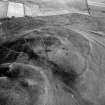
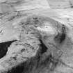
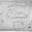
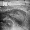
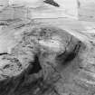
(Location cited as NY 186 788). Situated upon a level portion of the imposing plateau on Birrenswark Hill, slightly below its highest point, and within the area of the hillfort, this monument commands extensive views over much of S Dumfriesshire.
Barbour sectioned this cairn during his excavation of the fort, revealing a central cist (possibly already disturbed) and some charred bone. The cist was enclosed and covered by an inner mound of clay which had in turn been covered by the stones of the cairn, which stood 5ft 6 ins (1.7m) high.
The cairn now forms a a clearly-defined turfed-over mound of stones measuring 24m in diameter and 1.2m in height and surmounted by a modern cairn. There is no trace of cist or kerb but there appears to be a quantity of clay in the building material.
M J Yates 1984.
Note (1997)
NY17NE 2.01 1869 7883
Listed as cairn.
RCAHMS 1997

